
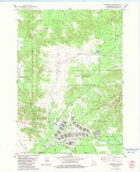
~ Alderwood Lake WI topo map, 1:24000 scale, 7.5 X 7.5 Minute, Historical, 1983, updated 1984
Alderwood Lake, Wisconsin, USGS topographic map dated 1983.
Includes geographic coordinates (latitude and longitude). This topographic map is suitable for hiking, camping, and exploring, or framing it as a wall map.
Printed on-demand using high resolution imagery, on heavy weight and acid free paper, or alternatively on a variety of synthetic materials.
Topos available on paper, Waterproof, Poly, or Tyvek. Usually shipping rolled, unless combined with other folded maps in one order.
- Product Number: USGS-6005627
- Free digital map download (high-resolution, GeoPDF): Alderwood Lake, Wisconsin (file size: 9 MB)
- Map Size: please refer to the dimensions of the GeoPDF map above
- Weight (paper map): ca. 55 grams
- Map Type: POD USGS Topographic Map
- Map Series: HTMC
- Map Verison: Historical
- Cell ID: 476
- Scan ID: 500007
- Imprint Year: 1984
- Woodland Tint: Yes
- Aerial Photo Year: 1978
- Edit Year: 1983
- Field Check Year: 1980
- Datum: NAD27
- Map Projection: Lambert Conformal Conic
- Map published by United States Geological Survey
- Map Language: English
- Scanner Resolution: 508 dpi
- Map Cell Name: Alderwood Lake
- Grid size: 7.5 X 7.5 Minute
- Date on map: 1983
- Map Scale: 1:24000
- Geographical region: Wisconsin, United States
Neighboring Maps:
All neighboring USGS topo maps are available for sale online at a variety of scales.
Spatial coverage:
Topo map Alderwood Lake, Wisconsin, covers the geographical area associated the following places:
- Tarr Creek - Camp McCoy - Hazel Dell Lake - Lemon Valley - Suukjak Sep Lake - Alder Lake WP358 Dam - Town of Lafayette - Fort McCoy - Dorn Cut - Stillwell Creek - Fort McCoy Police Department - Upper Sparta Pond - Alderwood Lake - Lafayette Cemetery - Tarr Valley - Alder Lake 19 - Suukjak Sep Creek - Town of New Lyme - Greenfield Fire Tower - Fort McCoy Fire Department Main Station - Sparta Creek
- Map Area ID: AREA44.12544-90.75-90.625
- Northwest corner Lat/Long code: USGSNW44.125-90.75
- Northeast corner Lat/Long code: USGSNE44.125-90.625
- Southwest corner Lat/Long code: USGSSW44-90.75
- Southeast corner Lat/Long code: USGSSE44-90.625
- Northern map edge Latitude: 44.125
- Southern map edge Latitude: 44
- Western map edge Longitude: -90.75
- Eastern map edge Longitude: -90.625


