
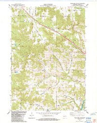
~ Stenulson Coulee WI topo map, 1:24000 scale, 7.5 X 7.5 Minute, Historical, 1984, updated 1984
Stenulson Coulee, Wisconsin, USGS topographic map dated 1984.
Includes geographic coordinates (latitude and longitude). This topographic map is suitable for hiking, camping, and exploring, or framing it as a wall map.
Printed on-demand using high resolution imagery, on heavy weight and acid free paper, or alternatively on a variety of synthetic materials.
Topos available on paper, Waterproof, Poly, or Tyvek. Usually shipping rolled, unless combined with other folded maps in one order.
- Product Number: USGS-6000580
- Free digital map download (high-resolution, GeoPDF): Stenulson Coulee, Wisconsin (file size: 10 MB)
- Map Size: please refer to the dimensions of the GeoPDF map above
- Weight (paper map): ca. 55 grams
- Map Type: POD USGS Topographic Map
- Map Series: HTMC
- Map Verison: Historical
- Cell ID: 43091
- Scan ID: 501945
- Imprint Year: 1984
- Woodland Tint: Yes
- Aerial Photo Year: 1982
- Edit Year: 1984
- Field Check Year: 1984
- Datum: NAD27
- Map Projection: Lambert Conformal Conic
- Map published by United States Geological Survey
- Map Language: English
- Scanner Resolution: 508 dpi
- Map Cell Name: Stenulson Coulee
- Grid size: 7.5 X 7.5 Minute
- Date on map: 1984
- Map Scale: 1:24000
- Geographical region: Wisconsin, United States
Neighboring Maps:
All neighboring USGS topo maps are available for sale online at a variety of scales.
Spatial coverage:
Topo map Stenulson Coulee, Wisconsin, covers the geographical area associated the following places:
- Squaw Creek Church - Pine Creek Cemetery - Ludeman G924 Dam - Stiehl Cemetery - Town Creek School (historical) - Spring Creek School (historical) - Town of Albion - Kenyon School (historical) - Lewis Airport - Papoose Creek School (historical) - Stenulson Coulee - WWIS-FM (Black River Falls) - Squaw Creek School - County Farm Cemetery - Papoose Creek - Cloverdale School (historical) - Shady Glen School (historical) - Oak Grove School (historical) - Lewis E6092 Dam - Hoffman Creek - 1.18 Reservoir - Spring Creek - 0.94 Reservoir - Kenyon Creek
- Map Area ID: AREA44.37544.25-91-90.875
- Northwest corner Lat/Long code: USGSNW44.375-91
- Northeast corner Lat/Long code: USGSNE44.375-90.875
- Southwest corner Lat/Long code: USGSSW44.25-91
- Southeast corner Lat/Long code: USGSSE44.25-90.875
- Northern map edge Latitude: 44.375
- Southern map edge Latitude: 44.25
- Western map edge Longitude: -91
- Eastern map edge Longitude: -90.875


