
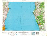
~ Milwaukee WI topo map, 1:250000 scale, 1 X 2 Degree, Historical, 1954, updated 1967
Milwaukee, Wisconsin, USGS topographic map dated 1954.
Includes geographic coordinates (latitude and longitude). This topographic map is suitable for hiking, camping, and exploring, or framing it as a wall map.
Printed on-demand using high resolution imagery, on heavy weight and acid free paper, or alternatively on a variety of synthetic materials.
Topos available on paper, Waterproof, Poly, or Tyvek. Usually shipping rolled, unless combined with other folded maps in one order.
- Product Number: USGS-5999294
- Free digital map download (high-resolution, GeoPDF): Milwaukee, Wisconsin (file size: 7 MB)
- Map Size: please refer to the dimensions of the GeoPDF map above
- Weight (paper map): ca. 55 grams
- Map Type: POD USGS Topographic Map
- Map Series: HTMC
- Map Verison: Historical
- Cell ID: 68912
- Scan ID: 503703
- Imprint Year: 1967
- Woodland Tint: Yes
- Aerial Photo Year: 1953
- Edit Year: 1966
- Datum: Unstated
- Map Projection: Transverse Mercator
- Map published by United States Army
- Map Language: English
- Scanner Resolution: 508 dpi
- Map Cell Name: Milwaukee
- Grid size: 1 X 2 Degree
- Date on map: 1954
- Map Scale: 1:250000
- Geographical region: Wisconsin, United States
Neighboring Maps:
All neighboring USGS topo maps are available for sale online at a variety of scales.
Spatial coverage:
Topo map Milwaukee, Wisconsin, covers the geographical area associated the following places:
- Ulao - Spring Lake - Sheboygan Falls - Updyke - Cloverville - Sheboygan - Glendale - Tallman - Gibbsville - Holton - Adell - Oostburg - Fredonia - Whitehall - Norton Shores - Haven - Fern - Epworth Assembly - Grafton - Franklin - Acacia Falls Mobile Home Court - North Muskegon - Timberline Estates Mobile Home Park - Custer - Shady Oaks Mobile Home Park - Mears - White Pine Village - Plymouth - Meeme - Cleveland Heights Mobile Home Park - Wiley - Hillcrest Mobile Home Park - Dalton - Little Point Sable - Idlewood Beach - Ada - Wayside Mobile Court - Louis Corners - Hidden Forest Mobile Home Park - Chauteau Norton Shores Mobile Home Park - Pentwater - Sylvan Beach - Crockery Mobile Home Park - Franklin Communities Mobile Home Park - Decker - Plymouth Country View Estates - Indian Meadows - Apple Carr Village - Twin Lake - Mosel - Millhome - North Epworth - Troy - Hingham - West Milwaukee - Hamilton - Pines Mobile Home Park - Berry Junction - Erdman - Ourtown - Carr - Montague - Weedens - Hart - Waubeka - Mequon - Belgium - Lakewood Club - Whitefish Bay - Shelby - Lake Church - Country Estates Mobile Home Park - Lakewood - Nomad Mobile Home Park - Kennedys Corners (historical) - Arlington Estates Mobile Village - Muskegon Heights - Hayen - Snug Harbor - Egelcraft Mobile Home Park - Ottawa Center - Roosevelt Park - Osman - Waldo - Holy Cross - Saint Huberts - Brunswick - Volney - Nunica - Newton - Mona Lake Mobile Home Park - Amber - Crystal Downs Mobile Village - Crystal Valley - Dacada - Hesperia - Colfax - Sitka - Wolf Lake - Sullivan
- Map Area ID: AREA4443-88-86
- Northwest corner Lat/Long code: USGSNW44-88
- Northeast corner Lat/Long code: USGSNE44-86
- Southwest corner Lat/Long code: USGSSW43-88
- Southeast corner Lat/Long code: USGSSE43-86
- Northern map edge Latitude: 44
- Southern map edge Latitude: 43
- Western map edge Longitude: -88
- Eastern map edge Longitude: -86


