
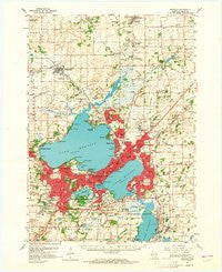
~ Madison WI topo map, 1:62500 scale, 15 X 15 Minute, Historical, 1959, updated 1965
Madison, Wisconsin, USGS topographic map dated 1959.
Includes geographic coordinates (latitude and longitude). This topographic map is suitable for hiking, camping, and exploring, or framing it as a wall map.
Printed on-demand using high resolution imagery, on heavy weight and acid free paper, or alternatively on a variety of synthetic materials.
Topos available on paper, Waterproof, Poly, or Tyvek. Usually shipping rolled, unless combined with other folded maps in one order.
- Product Number: USGS-5998998
- Free digital map download (high-resolution, GeoPDF): Madison, Wisconsin (file size: 5 MB)
- Map Size: please refer to the dimensions of the GeoPDF map above
- Weight (paper map): ca. 55 grams
- Map Type: POD USGS Topographic Map
- Map Series: HTMC
- Map Verison: Historical
- Cell ID: 57039
- Scan ID: 802873
- Imprint Year: 1965
- Woodland Tint: Yes
- Aerial Photo Year: 1957
- Datum: NAD27
- Map Projection: Polyconic
- Map published by United States Geological Survey
- Map Language: English
- Scanner Resolution: 508 dpi
- Map Cell Name: Madison
- Grid size: 15 X 15 Minute
- Date on map: 1959
- Map Scale: 1:62500
- Geographical region: Wisconsin, United States
Neighboring Maps:
All neighboring USGS topo maps are available for sale online at a variety of scales.
Spatial coverage:
Topo map Madison, Wisconsin, covers the geographical area associated the following places:
- Foxmoor Hills - Syene (historical) - Lake Waubesa - Highland Manor - Sherwood Glen - Elmside - Windsor - Kingsley Corners - Monona - College Hills - South Madison - Lake Windsor - Mendota Beach - Maple Bluff - Ethelwyn Park - Oakland Heights - Pheasant Branch - Greenbush Addition - Tonyawatha - Token Creek - Wynbrooke - Wingra Park - Preglers Addition - McFarland - Hoepkers Corners - De Forest - Madison - Mendota - Pilgrim Village - Oak Park Terrace - Burke - Warrens Addition - Raintree - Darwin (historical) - Madison Mobile Home Park - Norway Grove - Catfish (historical) - Shorewood Hills - Waunakee - Sunburst - Bowens Addition
- Map Area ID: AREA43.2543-89.5-89.25
- Northwest corner Lat/Long code: USGSNW43.25-89.5
- Northeast corner Lat/Long code: USGSNE43.25-89.25
- Southwest corner Lat/Long code: USGSSW43-89.5
- Southeast corner Lat/Long code: USGSSE43-89.25
- Northern map edge Latitude: 43.25
- Southern map edge Latitude: 43
- Western map edge Longitude: -89.5
- Eastern map edge Longitude: -89.25


