
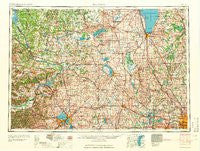
~ Madison WI topo map, 1:250000 scale, 1 X 2 Degree, Historical, 1960
Madison, Wisconsin, USGS topographic map dated 1960.
Includes geographic coordinates (latitude and longitude). This topographic map is suitable for hiking, camping, and exploring, or framing it as a wall map.
Printed on-demand using high resolution imagery, on heavy weight and acid free paper, or alternatively on a variety of synthetic materials.
Topos available on paper, Waterproof, Poly, or Tyvek. Usually shipping rolled, unless combined with other folded maps in one order.
- Product Number: USGS-5998996
- Free digital map download (high-resolution, GeoPDF): Madison, Wisconsin (file size: 12 MB)
- Map Size: please refer to the dimensions of the GeoPDF map above
- Weight (paper map): ca. 55 grams
- Map Type: POD USGS Topographic Map
- Map Series: HTMC
- Map Verison: Historical
- Cell ID: 68887
- Scan ID: 802872
- Woodland Tint: Yes
- Field Check Year: 1957
- Survey Year: 1957
- Datum: Unstated
- Map Projection: Transverse Mercator
- Map published by United States Geological Survey
- Map Language: English
- Scanner Resolution: 508 dpi
- Map Cell Name: Madison
- Grid size: 1 X 2 Degree
- Date on map: 1960
- Map Scale: 1:250000
- Geographical region: Wisconsin, United States
Neighboring Maps:
All neighboring USGS topo maps are available for sale online at a variety of scales.
Spatial coverage:
Topo map Madison, Wisconsin, covers the geographical area associated the following places:
- Wilmoore Heights - Green Lake - Okauchee - Elo - Brandon - Dellwood - Germania - Saint Anthony - Delafield - Gooseville - Dellwood - Elmore - LeRoy - Taylors Corners - Breezy Knoll - Quincy (historical) - Lowville - Durwards Glen - Beechwood - Saint Kilian - Huilsburg - Oak Grove - Menomonee Falls - London - Aztalan - Thompson - Rock River Mobile Home Park - Highland Park - Fairburn - Mayville - Garnet - Mendota Beach - Klevenville - Johnsburg - North Leeds - Herman Center - Brooks - Denzer - New Chester (historical) - Black Wolf - Hoopers Mill - East Waupun - Markesan - Five Points - Ridgeway - McFarland - Otsego - Lewiston - Douglas Center - Danville - Taycheedah - Diefenbach Corners - Chinatown - Vermont - Pipe - Mount Calvary - Warrens Addition - Hartford - Neosho - Sherwood Forest - Winnebago Heights - Sun Prairie - New Prospect - Merton - Duplainville - Poynette - Dousman - Richfield - Adams Center (historical) - Minawa Beach - Blue Mounds - Paukotuk - Cedar Lake - Calumetville - Johnson Creek - Sunburst - South Madison - De Forest - Ring - Fox Lake Junction - Graham Corners - Victory Center - Bowens Addition - Raintree - Springfield Corners - Ashippun - Plainville - LaRue - Hope - Farmington - Newburg - Willow Springs - Cambria - Fillmore - York Center - Marytown - Rockfield - Pheasant Branch - Concord - Morrisonville
- Map Area ID: AREA4443-90-88
- Northwest corner Lat/Long code: USGSNW44-90
- Northeast corner Lat/Long code: USGSNE44-88
- Southwest corner Lat/Long code: USGSSW43-90
- Southeast corner Lat/Long code: USGSSE43-88
- Northern map edge Latitude: 44
- Southern map edge Latitude: 43
- Western map edge Longitude: -90
- Eastern map edge Longitude: -88


