
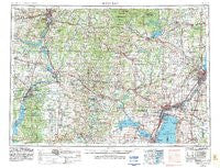
~ Green Bay WI topo map, 1:250000 scale, 1 X 2 Degree, Historical, 1955, updated 1983
Green Bay, Wisconsin, USGS topographic map dated 1955.
Includes geographic coordinates (latitude and longitude). This topographic map is suitable for hiking, camping, and exploring, or framing it as a wall map.
Printed on-demand using high resolution imagery, on heavy weight and acid free paper, or alternatively on a variety of synthetic materials.
Topos available on paper, Waterproof, Poly, or Tyvek. Usually shipping rolled, unless combined with other folded maps in one order.
- Product Number: USGS-5998238
- Free digital map download (high-resolution, GeoPDF): Green Bay, Wisconsin (file size: 13 MB)
- Map Size: please refer to the dimensions of the GeoPDF map above
- Weight (paper map): ca. 55 grams
- Map Type: POD USGS Topographic Map
- Map Series: HTMC
- Map Verison: Historical
- Cell ID: 68806
- Scan ID: 503712
- Imprint Year: 1983
- Woodland Tint: Yes
- Aerial Photo Year: 1978
- Edit Year: 1982
- Field Check Year: 1955
- Datum: NAD27
- Map Projection: Transverse Mercator
- Map published by: Military, Other
- Map Language: English
- Scanner Resolution: 508 dpi
- Map Cell Name: Green Bay
- Grid size: 1 X 2 Degree
- Date on map: 1955
- Map Scale: 1:250000
- Geographical region: Wisconsin, United States
Neighboring Maps:
All neighboring USGS topo maps are available for sale online at a variety of scales.
Spatial coverage:
Topo map Green Bay, Wisconsin, covers the geographical area associated the following places:
- Wisconsin Rapids - Saxeville - Cottonville - Pulcifer - Sherry - Shiocton - South Chase - Holland - Wittenberg - Biron - Whiting - Moon - Edgar - Bear Creek Corners - Lena - East Hill - Waupaca - Chase - Stettin (historical) - Menasha - Blenker - Elm Tree Corners - Hunting - Neenah - New Rome - Black Creek - Wausau - Wrightstown - West Almond - Nicholson - Green Bay - Plover - Fancher - Adella Beach - Hilbert Junction - Bevent - Pine River - Dancy - West De Pere - Winchester - Morgan - Kimberly - Mill Creek Community - Ellis - Twelve Corners - Strongs Prairie - Baldwins Mill - Neopit - Sunrise Bay - Knowlton - New London - Nekoosa Junction - Regina - Middle Village - Oakwood - High Cliff (historical) - Advance - Quinney - Center Valley - Schofield - Slab City - Eland - Granite City (historical) - Eureka - Leeman - Navarino - Legend Lake - Wausau Junction - Little Suamico - Rockaway Beach - Pittsfield - Suamico - Waverly Beach - Peplin - Lunds - Sheridan - River View Mobile Home Park - Park Ridge - Frazer Corners - Hobart Mobile Home Park - Zittau - Morgan - Ringle - Mount View - Greenleaf - Combined Locks - Appleton - Blaine - Caroline - De Pere - Split Rock - Milladore - Sobieski Corners - Red Banks - Askeaton - Junction City - Cecil - Little Waupon - Norske - Callon
- Map Area ID: AREA4544-90-88
- Northwest corner Lat/Long code: USGSNW45-90
- Northeast corner Lat/Long code: USGSNE45-88
- Southwest corner Lat/Long code: USGSSW44-90
- Southeast corner Lat/Long code: USGSSE44-88
- Northern map edge Latitude: 45
- Southern map edge Latitude: 44
- Western map edge Longitude: -90
- Eastern map edge Longitude: -88


