
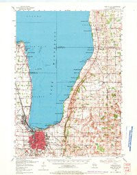
~ Fond Du Lac WI topo map, 1:62500 scale, 15 X 15 Minute, Historical, 1955, updated 1971
Fond Du Lac, Wisconsin, USGS topographic map dated 1955.
Includes geographic coordinates (latitude and longitude). This topographic map is suitable for hiking, camping, and exploring, or framing it as a wall map.
Printed on-demand using high resolution imagery, on heavy weight and acid free paper, or alternatively on a variety of synthetic materials.
Topos available on paper, Waterproof, Poly, or Tyvek. Usually shipping rolled, unless combined with other folded maps in one order.
- Product Number: USGS-5998052
- Free digital map download (high-resolution, GeoPDF): Fond Du Lac, Wisconsin (file size: 6 MB)
- Map Size: please refer to the dimensions of the GeoPDF map above
- Weight (paper map): ca. 55 grams
- Map Type: POD USGS Topographic Map
- Map Series: HTMC
- Map Verison: Historical
- Cell ID: 54223
- Scan ID: 502392
- Imprint Year: 1971
- Woodland Tint: Yes
- Aerial Photo Year: 1952
- Survey Year: 1955
- Datum: NAD27
- Map Projection: Polyconic
- Map published by United States Geological Survey
- Map Language: English
- Scanner Resolution: 508 dpi
- Map Cell Name: Fond du Lac
- Grid size: 15 X 15 Minute
- Date on map: 1955
- Map Scale: 1:62500
- Geographical region: Wisconsin, United States
Neighboring Maps:
All neighboring USGS topo maps are available for sale online at a variety of scales.
Spatial coverage:
Topo map Fond Du Lac, Wisconsin, covers the geographical area associated the following places:
- Taycheedah - Winnebago Park - Luco - Black Wolf Point - Saint Peter - Artesia Beach - Linden Beach - Brothertown - Johnsburg - Decorah Beach - Silica - Pipe - Calumetville - Peebles - Hopokoekau Beach - Welling Beach - Laudolff Beach - Point Comfort - Gladstone Beach - Dotyville - Pukwana Beach - Bergen Beach - Maple Heights - Fond du Lac - Jericho - Highland Park - Malone - Calumet Harbor - North Fond du Lac - Winnebago Heights - Garnet - Dexter - Little Point - Minawa Beach
- Map Area ID: AREA4443.75-88.5-88.25
- Northwest corner Lat/Long code: USGSNW44-88.5
- Northeast corner Lat/Long code: USGSNE44-88.25
- Southwest corner Lat/Long code: USGSSW43.75-88.5
- Southeast corner Lat/Long code: USGSSE43.75-88.25
- Northern map edge Latitude: 44
- Southern map edge Latitude: 43.75
- Western map edge Longitude: -88.5
- Eastern map edge Longitude: -88.25


