
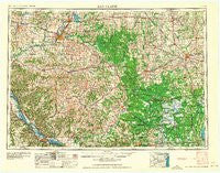
~ Eau Claire WI topo map, 1:250000 scale, 1 X 2 Degree, Historical, 1964
Eau Claire, Wisconsin, USGS topographic map dated 1964.
Includes geographic coordinates (latitude and longitude). This topographic map is suitable for hiking, camping, and exploring, or framing it as a wall map.
Printed on-demand using high resolution imagery, on heavy weight and acid free paper, or alternatively on a variety of synthetic materials.
Topos available on paper, Waterproof, Poly, or Tyvek. Usually shipping rolled, unless combined with other folded maps in one order.
- Product Number: USGS-5997858
- Free digital map download (high-resolution, GeoPDF): Eau Claire, Wisconsin (file size: 12 MB)
- Map Size: please refer to the dimensions of the GeoPDF map above
- Weight (paper map): ca. 55 grams
- Map Type: POD USGS Topographic Map
- Map Series: HTMC
- Map Verison: Historical
- Cell ID: 68763
- Scan ID: 801533
- Woodland Tint: Yes
- Aerial Photo Year: 1953
- Field Check Year: 1953
- Datum: Unstated
- Map Projection: Transverse Mercator
- Map published by United States Geological Survey
- Map Language: English
- Scanner Resolution: 508 dpi
- Map Cell Name: Eau Claire
- Grid size: 1 X 2 Degree
- Date on map: 1964
- Map Scale: 1:250000
- Geographical region: Wisconsin, United States
Neighboring Maps:
All neighboring USGS topo maps are available for sale online at a variety of scales.
Spatial coverage:
Topo map Eau Claire, Wisconsin, covers the geographical area associated the following places:
- Lima - Country Valley Mobile Home Park - Christie - Green Acres - Shawtown - Seymour - Clay (historical) - Villa Diann Mobile Home Park - Stratford - Whitman - Weaver - Caryville - Boyd - Tell - Swan - Charter Oak Mills (historical) - Cochrane - Bethany - Burr Oak - Cleghorn - Fairchild - Kellogg - Hewitt - Colby - Sheppard - Wilson - Frenchville - Willard - Melrose - Hillcrest Estates Mobile Home Park - Irving - Taylor - Mindoro - Pittsville - Rock Falls - Durand - Winnebago Mission - Cloverdale - Humbird - Fall Creek - Bluff Siding - Longwood - Cream - Upper French Creek - Pine Creek (historical) - Marshland - Meadow Valley - Stanley - Howard - Hemlock - Sugarloaf - Colfax - Arcadia - Sidney - York - Chippewa Falls - Mount Hope Corners - Downsville - Blair - Fountain City - Milan - Countryside Manor Mobile Home Park - Mondovi - Shennington - Auburndale - Wuertsburg - Lookout - Morningside Terrace - Pleasantville - Osseo - Thorp - Hale - Merrillan - Greenwood - Cedar Falls - Spaulding - Shortville - Mann - Bateman - Alma - Riplinger - Pine Grove - Cataract - Weber - Marshfield - Waterbury - Iduna - Arpin - East Winona - Allen - Spring Bank Park - Tamarack - Spokeville - Cadott - Elk Mound - Huber Mobile Home Park - Nasonville - Northfield - Cortland (historical) - Lombard
- Map Area ID: AREA4544-92-90
- Northwest corner Lat/Long code: USGSNW45-92
- Northeast corner Lat/Long code: USGSNE45-90
- Southwest corner Lat/Long code: USGSSW44-92
- Southeast corner Lat/Long code: USGSSE44-90
- Northern map edge Latitude: 45
- Southern map edge Latitude: 44
- Western map edge Longitude: -92
- Eastern map edge Longitude: -90


