
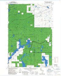
~ Diamond Lake WI topo map, 1:24000 scale, 7.5 X 7.5 Minute, Historical, 1971, updated 1985
Diamond Lake, Wisconsin, USGS topographic map dated 1971.
Includes geographic coordinates (latitude and longitude). This topographic map is suitable for hiking, camping, and exploring, or framing it as a wall map.
Printed on-demand using high resolution imagery, on heavy weight and acid free paper, or alternatively on a variety of synthetic materials.
Topos available on paper, Waterproof, Poly, or Tyvek. Usually shipping rolled, unless combined with other folded maps in one order.
- Product Number: USGS-5997722
- Free digital map download (high-resolution, GeoPDF): Diamond Lake, Wisconsin (file size: 11 MB)
- Map Size: please refer to the dimensions of the GeoPDF map above
- Weight (paper map): ca. 55 grams
- Map Type: POD USGS Topographic Map
- Map Series: HTMC
- Map Verison: Historical
- Cell ID: 12199
- Scan ID: 501743
- Imprint Year: 1985
- Woodland Tint: Yes
- Aerial Photo Year: 1981
- Edit Year: 1983
- Field Check Year: 1971
- Datum: NAD27
- Map Projection: Polyconic
- Map published by United States Geological Survey
- Map Language: English
- Scanner Resolution: 508 dpi
- Map Cell Name: Diamond Lake
- Grid size: 7.5 X 7.5 Minute
- Date on map: 1971
- Map Scale: 1:24000
- Geographical region: Wisconsin, United States
Neighboring Maps:
All neighboring USGS topo maps are available for sale online at a variety of scales.
Spatial coverage:
Topo map Diamond Lake, Wisconsin, covers the geographical area associated the following places:
- Lake Sixteen - Little Hidden Lake - Lake Owen Summer Homes Group - Two Lakes Campground - Virgin Pine Trail - Ryberg Lake - Tank Lake - Johnson Springs - Lake Owen Dam - North Country Trail - Diamond Lake - Northeast Lake - Sage Lake - Deer Lick Lake - Johnson Springs 3WR211 Dam - Adeline Lake - Johnson Spring Flowage 1 - Lake Ree - Roger Lake - Eighteenmile Creek Springs - Porcupine Lake - Ramstead Creek - Lake Owen Picnic Area - Sugar Bush Lake - Drummond Census Designated Place - Overby Lake - Crane Lake - Porcupine Creek - Bass Lake - Coburn Lake - Porcupine Lake Wilderness - Pot Lake - Lake Owen - Lake Owen Outlet Picnic Area - Grass Lake
- Map Area ID: AREA46.37546.25-91.25-91.125
- Northwest corner Lat/Long code: USGSNW46.375-91.25
- Northeast corner Lat/Long code: USGSNE46.375-91.125
- Southwest corner Lat/Long code: USGSSW46.25-91.25
- Southeast corner Lat/Long code: USGSSE46.25-91.125
- Northern map edge Latitude: 46.375
- Southern map edge Latitude: 46.25
- Western map edge Longitude: -91.25
- Eastern map edge Longitude: -91.125


