
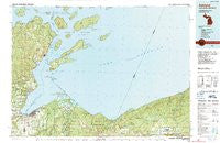
~ Ashland WI topo map, 1:100000 scale, 30 X 60 Minute, Historical, 1989
Ashland, Wisconsin, USGS topographic map dated 1989.
Includes geographic coordinates (latitude and longitude). This topographic map is suitable for hiking, camping, and exploring, or framing it as a wall map.
Printed on-demand using high resolution imagery, on heavy weight and acid free paper, or alternatively on a variety of synthetic materials.
Topos available on paper, Waterproof, Poly, or Tyvek. Usually shipping rolled, unless combined with other folded maps in one order.
- Product Number: USGS-5997144
- Free digital map download (high-resolution, GeoPDF): Ashland, Wisconsin (file size: 21 MB)
- Map Size: please refer to the dimensions of the GeoPDF map above
- Weight (paper map): ca. 55 grams
- Map Type: POD USGS Topographic Map
- Map Series: HTMC
- Map Verison: Historical
- Cell ID: 67067
- Scan ID: 503638
- Woodland Tint: Yes
- Aerial Photo Year: 1984
- Edit Year: 1989
- Datum: NAD27
- Map Projection: Universal Transverse Mercator
- Map published by United States Geological Survey
- Map Language: English
- Scanner Resolution: 508 dpi
- Map Cell Name: Ashland
- Grid size: 30 X 60 Minute
- Date on map: 1989
- Map Scale: 1:100000
- Geographical region: Wisconsin, United States
Neighboring Maps:
All neighboring USGS topo maps are available for sale online at a variety of scales.
Spatial coverage:
Topo map Ashland, Wisconsin, covers the geographical area associated the following places:
- Auvinen Corner - Hautala Corner - Cedar - Odanah - Pureair - Bayfield - Junet - Red Cliff - Washburn - Middleport - Old Fort - Sand Bay - Ashland Junction - Camp Dejacket - Sioux - Ashland - North Bessemer - Salmo - La Pointe - Birch - White River - Barksdale - North Ironwood
- Map Area ID: AREA4746.5-91-90
- Northwest corner Lat/Long code: USGSNW47-91
- Northeast corner Lat/Long code: USGSNE47-90
- Southwest corner Lat/Long code: USGSSW46.5-91
- Southeast corner Lat/Long code: USGSSE46.5-90
- Northern map edge Latitude: 47
- Southern map edge Latitude: 46.5
- Western map edge Longitude: -91
- Eastern map edge Longitude: -90


