
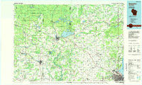
~ Shawano WI topo map, 1:100000 scale, 30 X 60 Minute, Historical, 1984, updated 1985
Shawano, Wisconsin, USGS topographic map dated 1984.
Includes geographic coordinates (latitude and longitude). This topographic map is suitable for hiking, camping, and exploring, or framing it as a wall map.
Printed on-demand using high resolution imagery, on heavy weight and acid free paper, or alternatively on a variety of synthetic materials.
Topos available on paper, Waterproof, Poly, or Tyvek. Usually shipping rolled, unless combined with other folded maps in one order.
- Product Number: USGS-5309798
- Free digital map download (high-resolution, GeoPDF): Shawano, Wisconsin (file size: 14 MB)
- Map Size: please refer to the dimensions of the GeoPDF map above
- Weight (paper map): ca. 55 grams
- Map Type: POD USGS Topographic Map
- Map Series: HTMC
- Map Verison: Historical
- Cell ID: 68352
- Scan ID: 803115
- Imprint Year: 1985
- Woodland Tint: Yes
- Aerial Photo Year: 1983
- Field Check Year: 1984
- Datum: NAD27
- Map Projection: Universal Transverse Mercator
- Planimetric: Yes
- Map published by United States Geological Survey
- Map Language: English
- Scanner Resolution: 508 dpi
- Map Cell Name: Shawano
- Grid size: 30 X 60 Minute
- Date on map: 1984
- Map Scale: 1:100000
- Geographical region: Wisconsin, United States
Neighboring Maps:
All neighboring USGS topo maps are available for sale online at a variety of scales.
Spatial coverage:
Topo map Shawano, Wisconsin, covers the geographical area associated the following places:
- Bear Creek Corners - Duck Creek - Hintz - Pittsfield - Leeman - Oconto Falls - Anston - Sobieski - Flintville - Cormier - Howard - Laney - South Chase - Bowler - Adams Beach - Briarton - Abrams - Leopolis - Rose Lawn - Sampson - Chase - Spruce - Pulaski - Nicholson - Shawano - Bear Creek - Pella - Isaar - Middle Village - Pleasant View Mobile Home Park - Advance - Gillett - Morgan - Zachow - Tilleda - Caroline - Gresham - Landstad - Underhill - Suamico - Symco - Seymour - Hunting - Camelot Terrace - Kelly Brook - Tremble - Buckbee - Stiles Junction - Marion - Hofa Park - Legend Lake - Kunesh - Lyndhurst - Clintonville - Frazer Corners - Granite City (historical) - Neopit - Morgan - Red River - Marble (historical) - Green Valley - Little Suamico - Almon - Thornton - Embarrass - Green Bay - Lunds - Krakow - Belle Plaine - Sobieski Corners - Hobart Mobile Home Park - Lena - Keshena - Nichols - Elm Tree Corners - Suring - Mosling - Angelica - Stiles - Mill Center - Cicero - Hayes - Pulcifer - Bonduel - Slab City - Navarino - Keshena Falls - Cecil
- Map Area ID: AREA4544.5-89-88
- Northwest corner Lat/Long code: USGSNW45-89
- Northeast corner Lat/Long code: USGSNE45-88
- Southwest corner Lat/Long code: USGSSW44.5-89
- Southeast corner Lat/Long code: USGSSE44.5-88
- Northern map edge Latitude: 45
- Southern map edge Latitude: 44.5
- Western map edge Longitude: -89
- Eastern map edge Longitude: -88


