
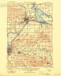
~ Chippewa Falls WI topo map, 1:62500 scale, 15 X 15 Minute, Historical, 1936, updated 1950
Chippewa Falls, Wisconsin, USGS topographic map dated 1936.
Includes geographic coordinates (latitude and longitude). This topographic map is suitable for hiking, camping, and exploring, or framing it as a wall map.
Printed on-demand using high resolution imagery, on heavy weight and acid free paper, or alternatively on a variety of synthetic materials.
Topos available on paper, Waterproof, Poly, or Tyvek. Usually shipping rolled, unless combined with other folded maps in one order.
- Product Number: USGS-5308626
- Free digital map download (high-resolution, GeoPDF): Chippewa Falls, Wisconsin (file size: 5 MB)
- Map Size: please refer to the dimensions of the GeoPDF map above
- Weight (paper map): ca. 55 grams
- Map Type: POD USGS Topographic Map
- Map Series: HTMC
- Map Verison: Historical
- Cell ID: 52531
- Scan ID: 801460
- Imprint Year: 1950
- Survey Year: 1934
- Datum: NAD27
- Map Projection: Polyconic
- Map published by United States Geological Survey
- Map Language: English
- Scanner Resolution: 508 dpi
- Map Cell Name: Chippewa Falls
- Grid size: 15 X 15 Minute
- Date on map: 1936
- Map Scale: 1:62500
- Geographical region: Wisconsin, United States
Neighboring Maps:
All neighboring USGS topo maps are available for sale online at a variety of scales.
Spatial coverage:
Topo map Chippewa Falls, Wisconsin, covers the geographical area associated the following places:
- Bateman - Anson - Chippewa Falls - Lake Hallie - Hallie - Eau Claire - Hillcrest Estates Mobile Home Park - Countryside Manor Mobile Home Park - Camino Mobile Home Park - Norma - Putnam Heights - Maples Mobile Home Park - Bluff Crest Mobile Home Park - Pinehurst - Altoona - Lake Wissota - Terrace Hill - Seymour - Irvine - Villa Diann Mobile Home Park - Fall Creek
- Map Area ID: AREA4544.75-91.5-91.25
- Northwest corner Lat/Long code: USGSNW45-91.5
- Northeast corner Lat/Long code: USGSNE45-91.25
- Southwest corner Lat/Long code: USGSSW44.75-91.5
- Southeast corner Lat/Long code: USGSSE44.75-91.25
- Northern map edge Latitude: 45
- Southern map edge Latitude: 44.75
- Western map edge Longitude: -91.5
- Eastern map edge Longitude: -91.25


