
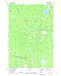
~ Coleman Lake WI topo map, 1:24000 scale, 7.5 X 7.5 Minute, Historical, 1972, updated 1974
Coleman Lake, Wisconsin, USGS topographic map dated 1972.
Includes geographic coordinates (latitude and longitude). This topographic map is suitable for hiking, camping, and exploring, or framing it as a wall map.
Printed on-demand using high resolution imagery, on heavy weight and acid free paper, or alternatively on a variety of synthetic materials.
Topos available on paper, Waterproof, Poly, or Tyvek. Usually shipping rolled, unless combined with other folded maps in one order.
- Product Number: USGS-5304838
- Free digital map download (high-resolution, GeoPDF): Coleman Lake, Wisconsin (file size: 6 MB)
- Map Size: please refer to the dimensions of the GeoPDF map above
- Weight (paper map): ca. 55 grams
- Map Type: POD USGS Topographic Map
- Map Series: HTMC
- Map Verison: Historical
- Cell ID: 9547
- Scan ID: 700104
- Imprint Year: 1974
- Woodland Tint: Yes
- Aerial Photo Year: 1971
- Field Check Year: 1972
- Datum: NAD27
- Map Projection: Lambert Conformal Conic
- Map published by United States Geological Survey
- Map Language: English
- Scanner Resolution: 508 dpi
- Map Cell Name: Coleman Lake
- Grid size: 7.5 X 7.5 Minute
- Date on map: 1972
- Map Scale: 1:24000
- Geographical region: Wisconsin, United States
Neighboring Maps:
All neighboring USGS topo maps are available for sale online at a variety of scales.
Spatial coverage:
Topo map Coleman Lake, Wisconsin, covers the geographical area associated the following places:
- Crooked Lake - Avery Creek - Coleman Lake - Benson Lake - Swede John Creek - Strong Falls - Trout Lake - Goodman County Park - Phillips Marsh - D'Amour Lake - Taylor Rapids - Brock G1536.2 Dam - Mirror Lake - Vic Lake - Goodman Census Designated Place - Chemical Creek - Camp F Creek - Round Lake - Brock Pond 34 - Harvey Creek - Woods Lake - Goodman Lookout Tower - Windsor Dam - Little Harvey Creek - Grandfather Lake - Brock Pond - Second Lake
- Map Area ID: AREA45.62545.5-88.375-88.25
- Northwest corner Lat/Long code: USGSNW45.625-88.375
- Northeast corner Lat/Long code: USGSNE45.625-88.25
- Southwest corner Lat/Long code: USGSSW45.5-88.375
- Southeast corner Lat/Long code: USGSSE45.5-88.25
- Northern map edge Latitude: 45.625
- Southern map edge Latitude: 45.5
- Western map edge Longitude: -88.375
- Eastern map edge Longitude: -88.25


