
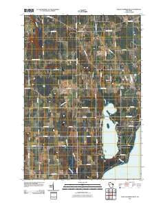
~ Baileys Harbor West WI topo map, 1:24000 scale, 7.5 X 7.5 Minute, Historical, 2010
Baileys Harbor West, Wisconsin, USGS topographic map dated 2010.
Includes geographic coordinates (latitude and longitude). This topographic map is suitable for hiking, camping, and exploring, or framing it as a wall map.
Printed on-demand using high resolution imagery, on heavy weight and acid free paper, or alternatively on a variety of synthetic materials.
Topos available on paper, Waterproof, Poly, or Tyvek. Usually shipping rolled, unless combined with other folded maps in one order.
- Product Number: USGS-5222438
- Free digital map download (high-resolution, GeoPDF): Baileys Harbor West, Wisconsin (file size: 18 MB)
- Map Size: please refer to the dimensions of the GeoPDF map above
- Weight (paper map): ca. 55 grams
- Map Type: POD USGS Topographic Map
- Map Series: US Topo
- Map Verison: Historical
- Cell ID: 2143
- Datum: North American Datum of 1983
- Map Projection: Transverse Mercator
- Map Cell Name: Baileys Harbor West
- Grid size: 7.5 X 7.5 Minute
- Date on map: 2010
- Map Scale: 1:24000
- Geographical region: Wisconsin, United States
Neighboring Maps:
All neighboring USGS topo maps are available for sale online at a variety of scales.
Spatial coverage:
Topo map Baileys Harbor West, Wisconsin, covers the geographical area associated the following places:
- Lighting Strikes Orchard - Baileys Harbor Volunteer Fire Department - Meridian County Park - Baileys Harbor Census Designated Place - Kangaroo Lake - Thorp Pond - Baileys Harbor Swamp - Sky Harbor Landing Strip (historical) - Button Marsh - Saint Paul's Lutheran Church - Heins Creek - Gray Air Dairy Farm - Gibraltar Fire Department - Door County Quarries - Maxwelton Country Club - Bley Farms - Baileys Harbor Cemetery - Jarman Quarry - Lyle-Harter-Matter County Park - Zion Church - Thorp Pond State Natural Area - Haberli Farms - Peil Creek - Kangaroo Lake State Natural Area - Boynton Chapel - Peninsula Center
- Map Area ID: AREA45.12545-87.25-87.125
- Northwest corner Lat/Long code: USGSNW45.125-87.25
- Northeast corner Lat/Long code: USGSNE45.125-87.125
- Southwest corner Lat/Long code: USGSSW45-87.25
- Southeast corner Lat/Long code: USGSSE45-87.125
- Northern map edge Latitude: 45.125
- Southern map edge Latitude: 45
- Western map edge Longitude: -87.25
- Eastern map edge Longitude: -87.125


