
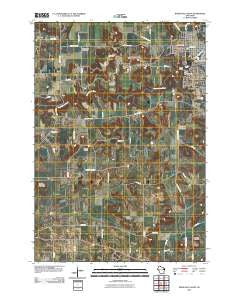
~ River Falls West WI topo map, 1:24000 scale, 7.5 X 7.5 Minute, Historical, 2010
River Falls West, Wisconsin, USGS topographic map dated 2010.
Includes geographic coordinates (latitude and longitude). This topographic map is suitable for hiking, camping, and exploring, or framing it as a wall map.
Printed on-demand using high resolution imagery, on heavy weight and acid free paper, or alternatively on a variety of synthetic materials.
Topos available on paper, Waterproof, Poly, or Tyvek. Usually shipping rolled, unless combined with other folded maps in one order.
- Product Number: USGS-5220764
- Free digital map download (high-resolution, GeoPDF): River Falls West, Wisconsin (file size: 13 MB)
- Map Size: please refer to the dimensions of the GeoPDF map above
- Weight (paper map): ca. 55 grams
- Map Type: POD USGS Topographic Map
- Map Series: US Topo
- Map Verison: Historical
- Cell ID: 38030
- Datum: North American Datum of 1983
- Map Projection: Transverse Mercator
- Map Cell Name: River Falls West
- Grid size: 7.5 X 7.5 Minute
- Date on map: 2010
- Map Scale: 1:24000
- Geographical region: Wisconsin, United States
Neighboring Maps:
All neighboring USGS topo maps are available for sale online at a variety of scales.
Spatial coverage:
Topo map River Falls West, Wisconsin, covers the geographical area associated the following places:
- Sand Hill School (historical) - Rocky Branch Elementary School - Tower Park - South Fork Kinnickinnic River - Mann Valley - Clifton Hollow School (historical) - Clifton Hollow Golf Club - Lone Mound - Oak Knoll School (historical) - Clifton Highlands Golf Course - Saint Bridget Cemetery - Lower Kinnickinnic Pond - Westside Elementary School - Sunnyside School (historical) - Upper Kinnickinnic Pond - May Hall - Riverside Square Shopping Mall - Ingram Center - Ashbaugh Mound - Junction Falls Dam - Wells Park - Powell Falls 2WP180 Dam - Rocky Branch - Melander Hill - Glen Park - Town of Clifton - Big River Presbyterian Cemetery - Renaissance Charter Academy - Glen Park Municipal Swimming Pool - Hillcrest Rest Home - Angel Hill School (historical) - Kinnickinnic State Park - Mann Valley Cemetery - Tegeler Airport (historical) - West Dale Park - Greenwood Valley Cemetery - Hagestad Student Center - Apostolic Church - Yorks Mound - Prucha Hall - Johnson Hall - Clifton Townhall - Glass Valley School (historical) - Lafette School (historical) - River Falls Public Montessori Academy - Mann Valley Church (historical) - Pierce Valley School (historical) - Stratton Hall
- Map Area ID: AREA44.87544.75-92.75-92.625
- Northwest corner Lat/Long code: USGSNW44.875-92.75
- Northeast corner Lat/Long code: USGSNE44.875-92.625
- Southwest corner Lat/Long code: USGSSW44.75-92.75
- Southeast corner Lat/Long code: USGSSE44.75-92.625
- Northern map edge Latitude: 44.875
- Southern map edge Latitude: 44.75
- Western map edge Longitude: -92.75
- Eastern map edge Longitude: -92.625


