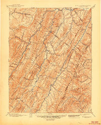
~ Franklin WV topo map, 1:125000 scale, 30 X 30 Minute, Historical, 1896, updated 1944
Franklin, West Virginia, USGS topographic map dated 1896.
Includes geographic coordinates (latitude and longitude). This topographic map is suitable for hiking, camping, and exploring, or framing it as a wall map.
Printed on-demand using high resolution imagery, on heavy weight and acid free paper, or alternatively on a variety of synthetic materials.
Topos available on paper, Waterproof, Poly, or Tyvek. Usually shipping rolled, unless combined with other folded maps in one order.
- Product Number: USGS-5638701
- Free digital map download (high-resolution, GeoPDF): Franklin, West Virginia (file size: 11 MB)
- Map Size: please refer to the dimensions of the GeoPDF map above
- Weight (paper map): ca. 55 grams
- Map Type: POD USGS Topographic Map
- Map Series: HTMC
- Map Verison: Historical
- Cell ID: 395864
- Scan ID: 253966
- Imprint Year: 1944
- Survey Year: 1895
- Datum: Unstated
- Map Projection: Polyconic
- Map published by United States Geological Survey
- Map Language: English
- Scanner Resolution: 600 dpi
- Map Cell Name: Franklin
- Grid size: 30 X 30 Minute
- Date on map: 1896
- Map Scale: 1:125000
- Geographical region: West Virginia, United States
Neighboring Maps:
All neighboring USGS topo maps are available for sale online at a variety of scales.
Spatial coverage:
Topo map Franklin, West Virginia, covers the geographical area associated the following places:
- Key (historical) - Landes - Simoda - Zigler - Mitchell - Riverton - Ketterman - Seneca Rocks - Milam - Peru - Brushy Run - Oak Grove - Harper - Mozer - Dorcas - Criders - Moatstown - Fort Seybert - Sweedlin - Rough Run - Wyoming (historical) - Seemly (historical) - Rawley Springs - Miles - Brandywine - Canaan Crossing - Franklin - Ruddle - Pansy - Moyers - Brake - Laneville - Masonville - Stringtown (historical) - Petersburg - Hiser (historical) - Hopeville - Cabins - Upper Tract - Sugar Grove - Clines Hacking - Bass - Propstburg - Fame - Oak Flat - Teterton - Onego - Macksville - Circleville - Harperton - Entry - Deer Run - Kline - Durgon - Dahmer - Monkeytown - Judy Gap
- Map Area ID: AREA3938.5-79.5-79
- Northwest corner Lat/Long code: USGSNW39-79.5
- Northeast corner Lat/Long code: USGSNE39-79
- Southwest corner Lat/Long code: USGSSW38.5-79.5
- Southeast corner Lat/Long code: USGSSE38.5-79
- Northern map edge Latitude: 39
- Southern map edge Latitude: 38.5
- Western map edge Longitude: -79.5
- Eastern map edge Longitude: -79