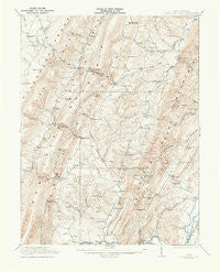
~ Greenland Gap WV topo map, 1:62500 scale, 15 X 15 Minute, Historical, 1921
Greenland Gap, West Virginia, USGS topographic map dated 1921.
Includes geographic coordinates (latitude and longitude). This topographic map is suitable for hiking, camping, and exploring, or framing it as a wall map.
Printed on-demand using high resolution imagery, on heavy weight and acid free paper, or alternatively on a variety of synthetic materials.
Topos available on paper, Waterproof, Poly, or Tyvek. Usually shipping rolled, unless combined with other folded maps in one order.
- Product Number: USGS-5415358
- Free digital map download (high-resolution, GeoPDF): Greenland Gap, West Virginia (file size: 9 MB)
- Map Size: please refer to the dimensions of the GeoPDF map above
- Weight (paper map): ca. 55 grams
- Map Type: POD USGS Topographic Map
- Map Series: HTMC
- Map Verison: Historical
- Cell ID: 54833
- Scan ID: 253558
- Survey Year: 1919
- Datum: NAD
- Map Projection: Polyconic
- Map published by United States Geological Survey
- Map Language: English
- Scanner Resolution: 600 dpi
- Map Cell Name: Greenland Gap
- Grid size: 15 X 15 Minute
- Date on map: 1921
- Map Scale: 1:62500
- Geographical region: West Virginia, United States
Neighboring Maps:
All neighboring USGS topo maps are available for sale online at a variety of scales.
Spatial coverage:
Topo map Greenland Gap, West Virginia, covers the geographical area associated the following places:
- Town Hill - Martin - Bismarck - Maysville - Lahmansville - Seymourville - Fisher - Oak Hill - Arthur - Scherr - Rig - Greenland - Walnut Bottom - Kline Gap - Kessel - Streby - Forman - Medley - Falls - Williamsport
- Map Area ID: AREA39.2539-79.25-79
- Northwest corner Lat/Long code: USGSNW39.25-79.25
- Northeast corner Lat/Long code: USGSNE39.25-79
- Southwest corner Lat/Long code: USGSSW39-79.25
- Southeast corner Lat/Long code: USGSSE39-79
- Northern map edge Latitude: 39.25
- Southern map edge Latitude: 39
- Western map edge Longitude: -79.25
- Eastern map edge Longitude: -79