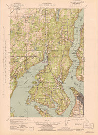
~ Gig Harbor WA topo map, 1:62500 scale, 15 X 15 Minute, Historical, 1943
Gig Harbor, Washington, USGS topographic map dated 1943.
Includes geographic coordinates (latitude and longitude). This topographic map is suitable for hiking, camping, and exploring, or framing it as a wall map.
Printed on-demand using high resolution imagery, on heavy weight and acid free paper, or alternatively on a variety of synthetic materials.
Topos available on paper, Waterproof, Poly, or Tyvek. Usually shipping rolled, unless combined with other folded maps in one order.
- Product Number: USGS-5409838
- Free digital map download (high-resolution, GeoPDF): Gig Harbor, Washington (file size: 7 MB)
- Map Size: please refer to the dimensions of the GeoPDF map above
- Weight (paper map): ca. 55 grams
- Map Type: POD USGS Topographic Map
- Map Series: HTMC
- Map Verison: Historical
- Cell ID: 54565
- Scan ID: 241265
- Woodland Tint: Yes
- Aerial Photo Year: 1937
- Datum: NAD27
- Map Projection: Polyconic
- Map published by United States Army Corps of Engineers
- Map published by United States Department of War
- Map Language: English
- Scanner Resolution: 600 dpi
- Map Cell Name: Gig Harbor
- Grid size: 15 X 15 Minute
- Date on map: 1943
- Map Scale: 1:62500
- Geographical region: Washington, United States
Neighboring Maps:
All neighboring USGS topo maps are available for sale online at a variety of scales.
Spatial coverage:
Topo map Gig Harbor, Washington, covers the geographical area associated the following places:
- Cove - Rosedale - Olympic View Mobile Manor - Sunshine Beach - Lisabeula - Forest Beach - Castlenook (historical) - Magnolia Heights - Shore Acres - Canterwood - Martell Mobile Manor - Key Center - Maplewood - Banner - Midway - Spring Beach - Wauna - Kitsap West Mobile Home Court - Ruston - Fort Nisqually - Glencove - Harborland Mobile Home Park - Purdy - West Anchor Mobile Home Park - Warren - Cromwell - Fragaria - Fox Island - Gig Harbor - Swede Hill - Glenwood - Peninsula Mobile Park - Wildwood - Tahlequah - Fox Island - Sunrise Beach - Harbor Heights - Wollochet - Arletta - Bayview - Olalla - Artondale - East Cromwell - Minter - Bethel - The Lakes Mobile Home Park - Burley - Lake Bay
- Map Area ID: AREA47.547.25-122.75-122.5
- Northwest corner Lat/Long code: USGSNW47.5-122.75
- Northeast corner Lat/Long code: USGSNE47.5-122.5
- Southwest corner Lat/Long code: USGSSW47.25-122.75
- Southeast corner Lat/Long code: USGSSE47.25-122.5
- Northern map edge Latitude: 47.5
- Southern map edge Latitude: 47.25
- Western map edge Longitude: -122.75
- Eastern map edge Longitude: -122.5