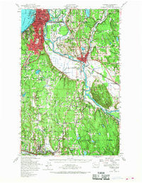
~ Everett WA topo map, 1:62500 scale, 15 X 15 Minute, Historical, 1953, updated 1968
Everett, Washington, USGS topographic map dated 1953.
Includes geographic coordinates (latitude and longitude). This topographic map is suitable for hiking, camping, and exploring, or framing it as a wall map.
Printed on-demand using high resolution imagery, on heavy weight and acid free paper, or alternatively on a variety of synthetic materials.
Topos available on paper, Waterproof, Poly, or Tyvek. Usually shipping rolled, unless combined with other folded maps in one order.
- Product Number: USGS-5409804
- Free digital map download (high-resolution, GeoPDF): Everett, Washington (file size: 11 MB)
- Map Size: please refer to the dimensions of the GeoPDF map above
- Weight (paper map): ca. 55 grams
- Map Type: POD USGS Topographic Map
- Map Series: HTMC
- Map Verison: Historical
- Cell ID: 53993
- Scan ID: 241091
- Imprint Year: 1968
- Woodland Tint: Yes
- Aerial Photo Year: 1952
- Survey Year: 1953
- Datum: NAD27
- Map Projection: Polyconic
- Map published by United States Geological Survey
- Map published by United States Army Corps of Engineers
- Map published by United States Army
- Map Language: English
- Scanner Resolution: 600 dpi
- Map Cell Name: Evertt
- Grid size: 15 X 15 Minute
- Date on map: 1953
- Map Scale: 1:62500
- Geographical region: Washington, United States
Neighboring Maps:
All neighboring USGS topo maps are available for sale online at a variety of scales.
Spatial coverage:
Topo map Everett, Washington, covers the geographical area associated the following places:
- Canyon Recreational Vehicle Park - Clearview - Country Carriage Estates Mobile Home Park - Three Lakes - Lakeview Mobile Home Park - Twin Creek Mobile Home Park - Canterbury Square Mobile Home Park - Lakewood Villa Mobile Home Park - Meridian Village Mobile Home - Fryelands - Canyon Park - Frontier Manor Mobile Home Park - Lockwood Village Mobile Home Park - Plantation Mobile Home Park - Country Manor Mobile Home Park - Circle H Mobile Home Park - Green Acres Mobile Home Park - Pinehurst - Maltby - Creekside Mobile Home Park - Murphys Corner - Snohomish - Goodrich Mobile Park - Bothell - Fourth Avenue West Estates Mobile Home Park - Lazy Wheels Mobile Park - Seattle Hill - Thrashers Corner - Mariner Village Mobile Home Park - North Creek - Cascade Vista Mobile Estates - Rees Corner - Village Green Mobile Home Park - Wintermutes Corner - Machias Mobile Manor - Thomas Place Mobile Home Park - Pilchuck Mobile Park - Sherwood Village Mobile Home Park - Lake Terrace Court Mobile Home Park - Northwest Mobile Home Park - Royal Coachman Mobile Home Park - Riverside Mobile Estates - Three Rivers Mobile Home Park - Sarvis Mobile Estates - Fobes Hill - Mill Creek - Larimers Corner - Echo Lake - Woodruff - Westridge Estates Mobile Home Park - Osborn Corner - Woodcrest Estates Mobile Home Park - Cardinal Estates Mobile Home Park - Grace - Halo Mobile Home Park - Everett - Mobile Country Club - Penny Lynn Mobile Home Park - Jamison Corner - Bromart - Lakewood Mobile Home Park - Kennard Corner - Snohomish Mobile Home Park - North Creek Mobile Home Park - Valley View Mobile Manor - Kennard Mobile Estates - Freeway Place Mobile Home Park - Lago de Plata Villa Mobile Home Park - Woodinville - Lowell - Canyon Mobile Park - Inglewood Estates Mobile Home Park - West Lake Stevens - Day City (historical) - Holly Hills Mobile Home Park - South Snohomish - Silver Shores Senior Mobile Home Park - Cavalero Corner - Casino Corner - Cathcart - Thunderbird Mobile Home Park - Everett Junction - Kenmore - Clearview Estates Mobile Home Park - Machias - Silver Firs - Turner Corner - Mount View Villa Mobile Home Park - Intercity - Lost Lake Mobile Home Park - Martha Lake - River Shores Mobile Home Park - Martha Lake Mobile Manor - Roosevelt
- Map Area ID: AREA4847.75-122.25-122
- Northwest corner Lat/Long code: USGSNW48-122.25
- Northeast corner Lat/Long code: USGSNE48-122
- Southwest corner Lat/Long code: USGSSW47.75-122.25
- Southeast corner Lat/Long code: USGSSE47.75-122
- Northern map edge Latitude: 48
- Southern map edge Latitude: 47.75
- Western map edge Longitude: -122.25
- Eastern map edge Longitude: -122