
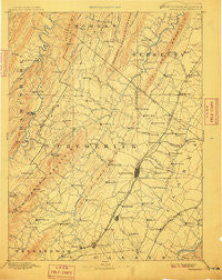
~ Winchester VA topo map, 1:125000 scale, 30 X 30 Minute, Historical, 1894, updated 1910
Winchester, Virginia, USGS topographic map dated 1894.
Includes geographic coordinates (latitude and longitude). This topographic map is suitable for hiking, camping, and exploring, or framing it as a wall map.
Printed on-demand using high resolution imagery, on heavy weight and acid free paper, or alternatively on a variety of synthetic materials.
Topos available on paper, Waterproof, Poly, or Tyvek. Usually shipping rolled, unless combined with other folded maps in one order.
- Product Number: USGS-5416174
- Free digital map download (high-resolution, GeoPDF): Winchester, Virginia (file size: 7 MB)
- Map Size: please refer to the dimensions of the GeoPDF map above
- Weight (paper map): ca. 55 grams
- Map Type: POD USGS Topographic Map
- Map Series: HTMC
- Map Verison: Historical
- Cell ID: 66958
- Scan ID: 189211
- Imprint Year: 1910
- Survey Year: 1885
- Datum: Unstated
- Map Projection: Unstated
- Map published by United States Geological Survey
- Map Language: English
- Scanner Resolution: 600 dpi
- Map Cell Name: Winchester
- Grid size: 30 X 30 Minute
- Date on map: 1894
- Map Scale: 1:125000
- Geographical region: Virginia, United States
Neighboring Maps:
All neighboring USGS topo maps are available for sale online at a variety of scales.
Spatial coverage:
Topo map Winchester, Virginia, covers the geographical area associated the following places:
- Blue Ridge Downs - Grimes - Stephens City - Bloom (historical) - Hogue Creek Estates - Nero (historical) - Claytonville - Rock Enon Springs - Parkins Mills - Waterloo Heights - Waterloo - Union Corner - Echo Village - Oranda - Blue Ridge Mobile Home Park - Spring Valley - North Mountain Estates - Wadesville - Milldale - Payne Mobile Home Park - Cabaniss - Armel - Tablers Station - Whitacre - Jericho (historical) - Sir John Addition - Sunnyside - Hooks Mills - Rock Hall - White Hall - Cather Estates - Mount Williams - Capon Springs - Greenway Court - Ashby - De Haveland Estates - Lebanon Church - Pyletown - Ridings Mill - Goose Nest - Gainesboro - Wheatfield - Southwood Hills - Keeneland - Sherwood Forest - Burning Knolls - Good - Westwood - Southview - Largent - Mosswood Hills - Indian Lake - Wellington Acres - Zepp - Burnt Factory - Keystone Estates - Winchester - Frederick Heights - Rolling Fields - The Knolls - Meadow Mills - Millwood - Middletown - Mount Hope - Lake Frederick - Ravenwood Estates - Bunker Hill - Shenandoah Hills - Finger Lake Estates - Swimley - Miller Heights - Nollville - Briggs - Mountain Falls - Bethel - Bubbling Spring - Freyco - Jordan Springs - College Park - North Frederick Terrace - Round Hill - White Post - Poplar Ridge - Ganotown - Rock Enon - Morton Grove - Grouse Hollow Estates - Glengary - Collinsville - Gordondale - Bloomery - Stephenson - Fairway Meadows - Hunters Valley - Shanghai - Welltown - Leetown - Lehew - Mountain View Acres - Bartonsville
- Map Area ID: AREA39.539-78.5-78
- Northwest corner Lat/Long code: USGSNW39.5-78.5
- Northeast corner Lat/Long code: USGSNE39.5-78
- Southwest corner Lat/Long code: USGSSW39-78.5
- Southeast corner Lat/Long code: USGSSE39-78
- Northern map edge Latitude: 39.5
- Southern map edge Latitude: 39
- Western map edge Longitude: -78.5
- Eastern map edge Longitude: -78


