
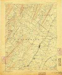
~ Winchester VA topo map, 1:125000 scale, 30 X 30 Minute, Historical, 1894, updated 1905
Winchester, Virginia, USGS topographic map dated 1894.
Includes geographic coordinates (latitude and longitude). This topographic map is suitable for hiking, camping, and exploring, or framing it as a wall map.
Printed on-demand using high resolution imagery, on heavy weight and acid free paper, or alternatively on a variety of synthetic materials.
Topos available on paper, Waterproof, Poly, or Tyvek. Usually shipping rolled, unless combined with other folded maps in one order.
- Product Number: USGS-5416172
- Free digital map download (high-resolution, GeoPDF): Winchester, Virginia (file size: 8 MB)
- Map Size: please refer to the dimensions of the GeoPDF map above
- Weight (paper map): ca. 55 grams
- Map Type: POD USGS Topographic Map
- Map Series: HTMC
- Map Verison: Historical
- Cell ID: 66958
- Scan ID: 189210
- Imprint Year: 1905
- Survey Year: 1885
- Datum: Unstated
- Map Projection: Unstated
- Map published by United States Geological Survey
- Map Language: English
- Scanner Resolution: 600 dpi
- Map Cell Name: Winchester
- Grid size: 30 X 30 Minute
- Date on map: 1894
- Map Scale: 1:125000
- Geographical region: Virginia, United States
Neighboring Maps:
All neighboring USGS topo maps are available for sale online at a variety of scales.
Spatial coverage:
Topo map Winchester, Virginia, covers the geographical area associated the following places:
- Stonebrook Farms - North Mountain Estates - Saratoga - Nineveh - Shockeysville - Fairway Meadows - Grouse Hollow Estates - Bufflick Heights - Day - Mar Village - Opequon - Waterloo - Swimley - Braddock Hills Estates - Payne Mobile Home Park - Jordan Springs - Westwood - Penry (historical) - Shiloh (historical) - Cedar Hill - Rock Enon - Southview - Woodchuck Heights - Burning Knolls - The Knolls - Inwood - Sunnyside - Klines Mill - Grimes - Wamplers Trailer Park - Blue Ridge Downs - Apple View Estates - Rolling Fields - Waterloo Heights - Milldale - Shenandoah Mobile Home Park - Country Club Heights - Ash Hollow Estates - Greenwood - Ashby - Stephenson - Cacapehon - Bethel - Arcadia Mobile Home Park - Sherwood Forest - Gerrardstown - Paxton Hills - Parkins Mills - Rock Hall - De Haveland Estates - De Haven - Poplar Ridge - Ole Orchard Estates - Echo Village - White Post - Frederick Heights - Pyletown - Mount Williams - Ravenwood Estates - Gordondale - Lincoln Estates - Blue Ridge Mobile Home Park - Claytonville - Cedar Grove - Greenwood Heights - Bunker Hill - Hayfield - Chapel Estates - Lost Corner - Hinckle - Gun Barrel Lane Estates - High View Manor - Wadesville - Zeiger - Briggs - Welltown - McQuire - Meadow Mills - Lake Frederick - Rosenberger - Arden - Cross Junction - Rock Enon Springs - Brucetown - Dearmont Chase - Armel - Good - Gravel Springs - Woodrow - Jericho (historical) - Lebanon Church - Wildwood Hills - Greenway Court - Valley Acres - Round Hill - Devland Estates - Brookneil - Mountain Falls - Canterburg - Chambersville - Nero (historical)
- Map Area ID: AREA39.539-78.5-78
- Northwest corner Lat/Long code: USGSNW39.5-78.5
- Northeast corner Lat/Long code: USGSNE39.5-78
- Southwest corner Lat/Long code: USGSSW39-78.5
- Southeast corner Lat/Long code: USGSSE39-78
- Northern map edge Latitude: 39.5
- Southern map edge Latitude: 39
- Western map edge Longitude: -78.5
- Eastern map edge Longitude: -78


