
~ Bedford VA topo map, 1:125000 scale, 30 X 30 Minute, Historical, 1891, updated 1932
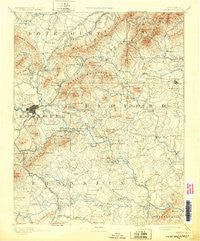
Bedford, Virginia, USGS topographic map dated 1891.
Includes geographic coordinates (latitude and longitude). This topographic map is suitable for hiking, camping, and exploring, or framing it as a wall map.
Printed on-demand using high resolution imagery, on heavy weight and acid free paper, or alternatively on a variety of synthetic materials.
Topos available on paper, Waterproof, Poly, or Tyvek. Usually shipping rolled, unless combined with other folded maps in one order.
- Product Number: USGS-5303750
- Free digital map download (high-resolution, GeoPDF): Bedford, Virginia (file size: 8 MB)
- Map Size: please refer to the dimensions of the GeoPDF map above
- Weight (paper map): ca. 55 grams
- Map Type: POD USGS Topographic Map
- Map Series: HTMC
- Map Verison: Historical
- Cell ID: 64972
- Scan ID: 188856
- Imprint Year: 1932
- Survey Year: 1888
- Datum: Unstated
- Map Projection: Polyconic
- Map published by United States Geological Survey
- Map Language: English
- Scanner Resolution: 600 dpi
- Map Cell Name: Bedford
- Grid size: 30 X 30 Minute
- Date on map: 1891
- Map Scale: 1:125000
- Geographical region: Virginia, United States
Neighboring Maps:
All neighboring USGS topo maps are available for sale online at a variety of scales.
Spatial coverage:
Topo map Bedford, Virginia, covers the geographical area associated the following places:
- Applewood - Melrose - Brookside - Dundee - Dugwell - Eagles Roost - Mill Mountain Estates - Meadowlark - Beulah Heights - Bedford - Hickman - Bonsack - Heritage Acres - Roanoke - Weaver Heights - Sherwood Forest - East Gate - Rosalind Hills - Isle of Pines - Fairview - Colonial Trail - Homeland Hills - Knollwood - Miller Court - Bratton Lawn - Old Dominion Court - Jamestown Place - Lincoln Court - Northfield - Runaway Village - Raleigh Court - Cave Alum Springs (historical) - Shadeland - North Hills - Crystal Spring - Southern Pines - Redwood - Hales Ford (historical) - Sunnybrook - Mountain View - Villa (historical) - Blue Ridge - Fairmount - Oakdale - Vista Heights - Greenfield - Round Hill Park - Countryside Estates - Narrows - Union Hall - Spring Grove - Blue Ridge Heights - Crafts Point - Cobleshaw - Captains Grove - Chapel Forest - Morningside - Meador - Fairland - Grandin Court - Spec - Town and Country - Mount Union - Hollins - Laurel Terrace - Clermont Heights - Burlington Heights - Foxfire - Stepping Stone - Meadewood - Arrington Court - Howell - Lakewood - Arrow Wood - Wyatt (historical) - La Bellevue - Otter View (historical) - Kenwood - Wildwood - Suncrest Heights - Pinkard Court - Arrowhead - Lilly View - Red Valley - Meadowland - North Hills - Timberidge Acres - Starmount - Cedar Bluff - Rosewood Park - Georgetown Park - Alpine Hills - Peakwood Hills - Stonebridge Acres - Flint Hill - Mapleton Heights - Monterey Hills - Ardmore - Jackson Park - Waverly
- Map Area ID: AREA37.537-80-79.5
- Northwest corner Lat/Long code: USGSNW37.5-80
- Northeast corner Lat/Long code: USGSNE37.5-79.5
- Southwest corner Lat/Long code: USGSSW37-80
- Southeast corner Lat/Long code: USGSSE37-79.5
- Northern map edge Latitude: 37.5
- Southern map edge Latitude: 37
- Western map edge Longitude: -80
- Eastern map edge Longitude: -79.5


