
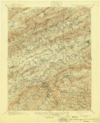
~ Abingdon VA topo map, 1:125000 scale, 30 X 30 Minute, Historical, 1911, updated 1945
Abingdon, Virginia, USGS topographic map dated 1911.
Includes geographic coordinates (latitude and longitude). This topographic map is suitable for hiking, camping, and exploring, or framing it as a wall map.
Printed on-demand using high resolution imagery, on heavy weight and acid free paper, or alternatively on a variety of synthetic materials.
Topos available on paper, Waterproof, Poly, or Tyvek. Usually shipping rolled, unless combined with other folded maps in one order.
- Product Number: USGS-5303724
- Free digital map download (high-resolution, GeoPDF): Abingdon, Virginia (file size: 10 MB)
- Map Size: please refer to the dimensions of the GeoPDF map above
- Weight (paper map): ca. 55 grams
- Map Type: POD USGS Topographic Map
- Map Series: HTMC
- Map Verison: Historical
- Cell ID: 64845
- Scan ID: 188836
- Imprint Year: 1945
- Survey Year: 1909
- Datum: Unstated
- Map Projection: Polyconic
- Map published by United States Geological Survey
- Map Language: English
- Scanner Resolution: 600 dpi
- Map Cell Name: Abingdon
- Grid size: 30 X 30 Minute
- Date on map: 1911
- Map Scale: 1:125000
- Geographical region: Virginia, United States
Neighboring Maps:
All neighboring USGS topo maps are available for sale online at a variety of scales.
Spatial coverage:
Topo map Abingdon, Virginia, covers the geographical area associated the following places:
- Blackwell - Tannersville - Wills - Roetown - Tuckerdale - Walker Place - Nella - Allison Gap - Ellendale - Harmon - Listening Rock - Plasterco - Fleet - Emory - Repass - Watauga - Keywood - Longhollow (historical) - Alvarado - Lodi - Page Hollow - Offset - Upper Shady - Chilhowie - Green Spring - Crandull - Old Glade Spring - Adwolf - Quebec - Clinchburg - Parks Mill - Whitetop - Duncanville - Henrytown - Brandon - Sulphur Springs Heights - Marion - Corn Valley - Delmar - Mock Mill - McCall Gap - Hanckel - Damascus - Winchester - Midway - Shady Grove - Hayter - De Busk Mill - Lick Skillet - McKees Store - Murrayfield - Dry Fork - Vance Mill - Cold Spring - Bethel - Cedar Branch - Riverside - Stone Mill - Drowning Ford - Fuller - Lindell - Apple Grove - Upper Shady - Smithfield - Vestal - McConnell - Snodgrass - Ketron Corner - Giesley Mill - Horseshoe Bend - Laureldale - Shady Valley - Clarksville - Silver Lake - Holston Mill - Cedar Bluff - Pleasant Heights - Widener Valley - North Holston - Rockdell - Greenfield - Camp Tom Howard - Osborns Store - Green Cove - Henderson - Seven Mile Ford - Loves Mill - Twin Oaks - Lowland - Meadowview - Osceola - Plum Creek - Stony Battery - Hubbard Junction - Neff - Ridgedale - Scott Addition - Hayters Gap - Rosedale - Eureka
- Map Area ID: AREA3736.5-82-81.5
- Northwest corner Lat/Long code: USGSNW37-82
- Northeast corner Lat/Long code: USGSNE37-81.5
- Southwest corner Lat/Long code: USGSSW36.5-82
- Southeast corner Lat/Long code: USGSSE36.5-81.5
- Northern map edge Latitude: 37
- Southern map edge Latitude: 36.5
- Western map edge Longitude: -82
- Eastern map edge Longitude: -81.5


