
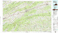
~ Wytheville VA topo map, 1:100000 scale, 30 X 60 Minute, Historical, 1982, updated 1988
Wytheville, Virginia, USGS topographic map dated 1982.
Includes geographic coordinates (latitude and longitude). This topographic map is suitable for hiking, camping, and exploring, or framing it as a wall map.
Printed on-demand using high resolution imagery, on heavy weight and acid free paper, or alternatively on a variety of synthetic materials.
Topos available on paper, Waterproof, Poly, or Tyvek. Usually shipping rolled, unless combined with other folded maps in one order.
- Product Number: USGS-5303710
- Free digital map download (high-resolution, GeoPDF): Wytheville, Virginia (file size: 25 MB)
- Map Size: please refer to the dimensions of the GeoPDF map above
- Weight (paper map): ca. 55 grams
- Map Type: POD USGS Topographic Map
- Map Series: HTMC
- Map Verison: Historical
- Cell ID: 68618
- Scan ID: 188818
- Imprint Year: 1988
- Woodland Tint: Yes
- Visual Version Number: 2
- Aerial Photo Year: 1975
- Edit Year: 1982
- Datum: NAD27
- Map Projection: Universal Transverse Mercator
- Map published by United States Geological Survey
- Map Language: English
- Scanner Resolution: 600 dpi
- Map Cell Name: Wytheville
- Grid size: 30 X 60 Minute
- Date on map: 1982
- Map Scale: 1:100000
- Geographical region: Virginia, United States
Neighboring Maps:
All neighboring USGS topo maps are available for sale online at a variety of scales.
Spatial coverage:
Topo map Wytheville, Virginia, covers the geographical area associated the following places:
- Bennington Mill - Furnace Hill - Nebo - Morningside Hills - Abingdon - Green Cove - Green Spring - Chatham Hill - Lowland - Riverside - Barton Crossroad - Elk Garden - Grayson - Adwolf - Creek Junction - Quebec - Musser - Keywood - Blacklick - Rugby - Shortsville - Edwards Crossroads - Chilhowie - Tannersville - Crandull - Henley - Roberts Mill - Groseclose Corner - Big Hill - Eureka - Crandull - Cline - Mock Mill - Henrytown - Blevins Crossroads - West Piney - Beaver - Whitetop - Catron (historical) - Plasterco - Ellendale - Collier - Camp Tom Howard - Neff - Fuller - Kings Creek - Greenfield - Groseclose - McKees Store - Midway - Duncanville - Scott Addition - Blackford - Chestnut Hill - Vestal - Rural Retreat - Sugar Grove - Grassy Creek - Apple Grove - McCready - Meadowview - Taylors Valley - Price Hill - Giesley Mill - Jacob (historical) - Stringtown - Flatwood - Weavers Ford - Peach Bottom - Masada - Longhollow (historical) - Sessex - Grant - Page Hollow - Sutherland - Blacksburg - Staley Crossroads - Bethel - Bridle Creek - Stratford - Konnarock - Marion - Hildreths House - Henderson - Vails Mill - Wills - Laureldale - Eagle (historical) - Atkins - Chestnut Grove - Litz - Hubbard Junction - Stone Mill - Baywood - Mill Creek - Holston Mill - Harr - Huddle - Clito Mill - Snodgrass
- Map Area ID: AREA3736.5-82-81
- Northwest corner Lat/Long code: USGSNW37-82
- Northeast corner Lat/Long code: USGSNE37-81
- Southwest corner Lat/Long code: USGSSW36.5-82
- Southeast corner Lat/Long code: USGSSE36.5-81
- Northern map edge Latitude: 37
- Southern map edge Latitude: 36.5
- Western map edge Longitude: -82
- Eastern map edge Longitude: -81


