
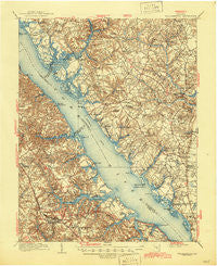
~ Williamsburg VA topo map, 1:62500 scale, 15 X 15 Minute, Historical, 1906, updated 1945
Williamsburg, Virginia, USGS topographic map dated 1906.
Includes geographic coordinates (latitude and longitude). This topographic map is suitable for hiking, camping, and exploring, or framing it as a wall map.
Printed on-demand using high resolution imagery, on heavy weight and acid free paper, or alternatively on a variety of synthetic materials.
Topos available on paper, Waterproof, Poly, or Tyvek. Usually shipping rolled, unless combined with other folded maps in one order.
- Product Number: USGS-5303586
- Free digital map download (high-resolution, GeoPDF): Williamsburg, Virginia (file size: 10 MB)
- Map Size: please refer to the dimensions of the GeoPDF map above
- Weight (paper map): ca. 55 grams
- Map Type: POD USGS Topographic Map
- Map Series: HTMC
- Map Verison: Historical
- Cell ID: 64555
- Scan ID: 188743
- Imprint Year: 1945
- Survey Year: 1904
- Datum: Unstated
- Map Projection: Polyconic
- Map published by United States Geological Survey
- Map Language: English
- Scanner Resolution: 600 dpi
- Map Cell Name: Williamsburg
- Grid size: 15 X 15 Minute
- Date on map: 1906
- Map Scale: 1:62500
- Geographical region: Virginia, United States
Neighboring Maps:
All neighboring USGS topo maps are available for sale online at a variety of scales.
Spatial coverage:
Topo map Williamsburg, Virginia, covers the geographical area associated the following places:
- Banbury Cross - Laurelwoods Estates Mobile Home Park - Queenswood - Skimino - West End - Winston Terrace - York Terrace - Bacons Quarters (historical) - Canterbury Hills - Parkway Estates - Creekwood Cove Estates - Old Stage Manor - Oaktree - Indigo Terrace - Plantation Heights - Gum Fork - Nelson Park - Wareham (historical) - Belleview - Signpine - Roane - Pinetta - Ewell - The Hamlet - Cheatham Annex - Millwood - Middletowne Farms - Clopton Heights - Charleston Heights - Concord (historical) - Woods Crossroads - Colonial Park - Springfield - White Marsh - Marlfield - Clay Bank Acres - Gressitt - Clay Bank - Village of Williamsburg - R and L Mobile Home Park - Ewell Hall - Walnut Hills - Country Village - Robert Heights - Wicomico - Harbor Hills - Ordinary - Porta Bello - Fort Magruder Heights - Oakdale - Allmondsville - Schenck Estates - Hermitage Banks - Charles Corner - Hayes - Bellamy - Magruder - Williamsburg Terrace Mobile Home Park - Gloucester - York View - Carp Circle - Carriage Heights - Adner - Burkes Corner - Berkeley Hills - James York Mobile Home Park - Greensprings - Ark - Gloucester Courthouse - Skipwith Farms - Williamsburg - Forest Hill Park - Olivers Estates - Powhatan Shores - York River Pines - The Mews - Springfield Terrace - Carver Gardens - Old Quaker Estates - Clopton - Hermitage - Rich Neck Heights - Jamestown Farms - Pinero - Rosewell - Shilsons Corner - Christensons Corner - Skimino Hills - Wan - Queens Lake - James Terrace - Belroi - Carters Cove - Druid Hills - Valley Front (historical) - Cappahosic Estates Mobile Home Park - Edgehill - Plain View - Neva Terrace - Chisel Run
- Map Area ID: AREA37.537.25-76.75-76.5
- Northwest corner Lat/Long code: USGSNW37.5-76.75
- Northeast corner Lat/Long code: USGSNE37.5-76.5
- Southwest corner Lat/Long code: USGSSW37.25-76.75
- Southeast corner Lat/Long code: USGSSE37.25-76.5
- Northern map edge Latitude: 37.5
- Southern map edge Latitude: 37.25
- Western map edge Longitude: -76.75
- Eastern map edge Longitude: -76.5


