
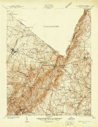
~ Berryville VA topo map, 1:48000 scale, 15 X 15 Minute, Historical, 1939
Berryville, Virginia, USGS topographic map dated 1939.
Includes geographic coordinates (latitude and longitude). This topographic map is suitable for hiking, camping, and exploring, or framing it as a wall map.
Printed on-demand using high resolution imagery, on heavy weight and acid free paper, or alternatively on a variety of synthetic materials.
Topos available on paper, Waterproof, Poly, or Tyvek. Usually shipping rolled, unless combined with other folded maps in one order.
- Product Number: USGS-5302494
- Free digital map download (high-resolution, GeoPDF): Berryville, Virginia (file size: 12 MB)
- Map Size: please refer to the dimensions of the GeoPDF map above
- Weight (paper map): ca. 55 grams
- Map Type: POD USGS Topographic Map
- Map Series: HTMC
- Map Verison: Historical
- Cell ID: 51251
- Scan ID: 188859
- Survey Year: 1939
- Datum: NAD27
- Map Projection: Polyconic
- Advance: Yes
- Map published by United States Geological Survey
- Map Language: English
- Scanner Resolution: 600 dpi
- Map Cell Name: Berryville
- Grid size: 15 X 15 Minute
- Date on map: 1939
- Map Scale: 1:48000
- Geographical region: Virginia, United States
Neighboring Maps:
All neighboring USGS topo maps are available for sale online at a variety of scales.
Spatial coverage:
Topo map Berryville, Virginia, covers the geographical area associated the following places:
- Crown Estates - Trapp Hill - Summit Point - Wheatland - Berrys - Lockes Landing - Treadwell - Paris Heights - Airmont - Unison - Arcadia Farm - Spout Run - Howardsville - Care Free Acres - Old Welbourne - Longview - Powells Grove - Round Hill - Frogtown - Valley View - Barker Land - Kinfield Estates - Eubanks - Fisher Hill - Kabletown - Randolph Corner - Lewisville - Wickliffe - Longmarsh Acres - Murphys Corner - Berryville - Bradfield - Webbtown - Mountain Lake - Rock Hill - Leithtown - Rockcroft - Bluemont - Pine Acres - Willow Lake - Paris - Willisville - Trapp - Littletown - Chilly Hollow Estates - Shannondale - Battletown - Mountain Mission - White Pump - Rippon - Welbourne - Calmes Neck Estates - Wilson - Ashby Run - Shenandoah Retreat - Apple Glen - Fairfield - Mannings - Top Hill - Sunny Ridge - River Park - Paxson - Meyerstown - Edgegrove - Gaylord - Castlemans Ferry - Vista Estates - Riverside - Saint Louis - Ashby Gap Estates - Pine Grove - Longwood - Horse Shoe Curve - Jamestown - Bloomfield - Franklintown - Wynkoop Mobile Home Park - Stringtown - Blue Ridge Estates - Miller
- Map Area ID: AREA39.2539-78-77.75
- Northwest corner Lat/Long code: USGSNW39.25-78
- Northeast corner Lat/Long code: USGSNE39.25-77.75
- Southwest corner Lat/Long code: USGSSW39-78
- Southeast corner Lat/Long code: USGSSE39-77.75
- Northern map edge Latitude: 39.25
- Southern map edge Latitude: 39
- Western map edge Longitude: -78
- Eastern map edge Longitude: -77.75


