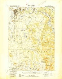
~ Burlington VT topo map, 1:62500 scale, 15 X 15 Minute, Historical, 1919
Burlington, Vermont, USGS topographic map dated 1919.
Includes geographic coordinates (latitude and longitude). This topographic map is suitable for hiking, camping, and exploring, or framing it as a wall map.
Printed on-demand using high resolution imagery, on heavy weight and acid free paper, or alternatively on a variety of synthetic materials.
Topos available on paper, Waterproof, Poly, or Tyvek. Usually shipping rolled, unless combined with other folded maps in one order.
- Product Number: USGS-5680057
- Free digital map download (high-resolution, GeoPDF): Burlington, Vermont (file size: 8 MB)
- Map Size: please refer to the dimensions of the GeoPDF map above
- Weight (paper map): ca. 55 grams
- Map Type: POD USGS Topographic Map
- Map Series: HTMC
- Map Verison: Historical
- Cell ID: 51941
- Scan ID: 460008
- Woodland Tint: Yes
- Datum: Unstated
- Map Projection: Unstated
- Map published by United States Army Corps of Engineers
- Map Language: English
- Scanner Resolution: 600 dpi
- Map Cell Name: Burlington
- Grid size: 15 X 15 Minute
- Date on map: 1919
- Map Scale: 1:62500
- Geographical region: Vermont, United States
Neighboring Maps:
All neighboring USGS topo maps are available for sale online at a variety of scales.
Spatial coverage:
Topo map Burlington, Vermont, covers the geographical area associated the following places:
- Williston - Shelburne - North Williston - Coleman Corner - Twin Orchards - South Burlington - Shelburne Falls - Queen City Park - North Ferrisburgh - Catlinsburg (historical) - Redstone Park - Rhode Island Corner - Mechanicsville - Hinesburg - Oakledge Park - Monkton Ridge - Kirby Corner - Fays Corner - South Hinesburg - Burlington - Winooski - Tafts Corner - Prindle Corners - Essex Junction - East Charlotte
- Map Area ID: AREA44.544.25-73.25-73
- Northwest corner Lat/Long code: USGSNW44.5-73.25
- Northeast corner Lat/Long code: USGSNE44.5-73
- Southwest corner Lat/Long code: USGSSW44.25-73.25
- Southeast corner Lat/Long code: USGSSE44.25-73
- Northern map edge Latitude: 44.5
- Southern map edge Latitude: 44.25
- Western map edge Longitude: -73.25
- Eastern map edge Longitude: -73