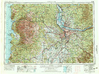
~ Vancouver WA topo map, 1:250000 scale, 1 X 2 Degree, Historical, 1958, updated 1976
Vancouver, Washington, USGS topographic map dated 1958.
Includes geographic coordinates (latitude and longitude). This topographic map is suitable for hiking, camping, and exploring, or framing it as a wall map.
Printed on-demand using high resolution imagery, on heavy weight and acid free paper, or alternatively on a variety of synthetic materials.
Topos available on paper, Waterproof, Poly, or Tyvek. Usually shipping rolled, unless combined with other folded maps in one order.
- Product Number: USGS-5689720
- Free digital map download (high-resolution, GeoPDF): Vancouver, Washington (file size: 29 MB)
- Map Size: please refer to the dimensions of the GeoPDF map above
- Weight (paper map): ca. 55 grams
- Map Type: POD USGS Topographic Map
- Map Series: HTMC
- Map Verison: Historical
- Cell ID: 396049
- Scan ID: 244450
- Imprint Year: 1976
- Woodland Tint: Yes
- Aerial Photo Year: 1973
- Edit Year: 1974
- Field Check Year: 1958
- Datum: Unstated
- Map Projection: Transverse Mercator
- Map published by: Military, Other
- Map Language: English
- Scanner Resolution: 600 dpi
- Map Cell Name: Vancouver
- Grid size: 1 X 2 Degree
- Date on map: 1958
- Map Scale: 1:250000
- Geographical region: Washington, United States
Neighboring Maps:
All neighboring USGS topo maps are available for sale online at a variety of scales.
Spatial coverage:
Topo map Vancouver, Washington, covers the geographical area associated the following places:
- Saint Johns - Vancouver Junction - Aldervale - Grand Ronde - Battin - Hamricks Corner - Enright - Powellhurst - Aurora - Unionvale - Sunset - Woodburn - Damascus Heights - Neskowin - Sandy - Lone Elder - Rose Lodge - Homan - Pleasant Home - Twin Rocks - View - Burlington - East Portland - Lambert - Liberal - Sheridan - South Scappoose - Broadmead - Sifton - Wheatland - Fairview - Perrydale - Somerset West - Hillsboro - Alameda - Johns Landing - Milwaukie Heights - Chelatchie - Kelso - Vernonia - Dodson - Rivergrove - Fairfield - Sunnyside - Monitor - Kenton - Amity - Columbia Heights - Bissell - Laurel - Glen Echo - Currinsville - Lunnville - Oceanside - Albina - Rockcreek - Dayton - Powell Valley - Deer Island - Brooks - Bethany - Mount Angel - Brightwood - Gales Creek - Plainview (historical) - Tracy - Marquam - Marmot - Hazeldale - Eola Crest - Timber - Jennings Lodge - Knapp - Cruzatt - Dodge - Garfield (historical) - Clarkes - Sunnycrest - Elwood - Manzanita - South Lake Oswego - Woodland - Lakewood - Canaan - Paradise Park - Treharne - Patton - Robinwood - Garden Home - Centerville (historical) - Mount Pleasant - Viola - Oak Grove - McNulty - Creswell Heights - Marylhurst - West Portland Park - Roads End - Dilley - Oak Park
- Map Area ID: AREA4645-124.0833333-122
- Northwest corner Lat/Long code: USGSNW46-124.0833333
- Northeast corner Lat/Long code: USGSNE46-122
- Southwest corner Lat/Long code: USGSSW45-124.0833333
- Southeast corner Lat/Long code: USGSSE45-122
- Northern map edge Latitude: 46
- Southern map edge Latitude: 45
- Western map edge Longitude: -124.0833333
- Eastern map edge Longitude: -122