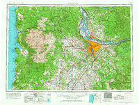
~ Vancouver WA topo map, 1:250000 scale, 1 X 2 Degree, Historical, 1958, updated 1968
Vancouver, Washington, USGS topographic map dated 1958.
Includes geographic coordinates (latitude and longitude). This topographic map is suitable for hiking, camping, and exploring, or framing it as a wall map.
Printed on-demand using high resolution imagery, on heavy weight and acid free paper, or alternatively on a variety of synthetic materials.
Topos available on paper, Waterproof, Poly, or Tyvek. Usually shipping rolled, unless combined with other folded maps in one order.
- Product Number: USGS-5689718
- Free digital map download (high-resolution, GeoPDF): Vancouver, Washington (file size: 24 MB)
- Map Size: please refer to the dimensions of the GeoPDF map above
- Weight (paper map): ca. 55 grams
- Map Type: POD USGS Topographic Map
- Map Series: HTMC
- Map Verison: Historical
- Cell ID: 396049
- Scan ID: 244447
- Imprint Year: 1968
- Woodland Tint: Yes
- Edit Year: 1967
- Field Check Year: 1958
- Datum: Unstated
- Map Projection: Transverse Mercator
- Map published by United States Army Corps of Engineers
- Map published by United States Army
- Map Language: English
- Scanner Resolution: 600 dpi
- Map Cell Name: Vancouver
- Grid size: 1 X 2 Degree
- Date on map: 1958
- Map Scale: 1:250000
- Geographical region: Washington, United States
Neighboring Maps:
All neighboring USGS topo maps are available for sale online at a variety of scales.
Spatial coverage:
Topo map Vancouver, Washington, covers the geographical area associated the following places:
- Butte Creek (historical) - Rivergrove - Helvetia - Battle Ground West - Henrici - Brightwood - Fishers Corner - Carus - Glen Echo - Hemlock - Chehalem - McLoughlin Heights - Woods - Bolton - Manning - Saint Johns - West Linn - Buell - Garden Home - Rex - Watts - Meda - Chapman Landing - Carver - Chapman - Lake Grove (historical) - Venersborg - Parkrose - Errol Heights - Mount Angel - Damascus - Powellhurst - Lunnville - Brighton - Twelvemile Corner - Broadmead - Carson Heights - Hobsonville - Scappoose - Central Point - McMinnville - Warrendale - Clear Creek - Whiteson - Johnson Crossing - Barton - Aldervale - Vinemaple - Foss - Milwaukie Heights - Hoodview - Wilsonville - North Howell - Charter Oak - Scotton Corner - Glencullen - Nedonna Beach - Dayton - Neahkahnie - Marylhurst - Woodburn - Centerville (historical) - Pleasant Valley - Tillamook - Kenton - Sandlake - Metzger - Brooklyn - Saint Joseph - Beaverton - Jennings Lodge - Fernwood - Columbia City - Canby - Mount Pleasant - Sandy - Irvington - Good Hope - Hidden - Dixie (historical) - Hazeldale - Elliott Prairie - Briarwood - Union - Monitor - Tualatin - Valley Junction - Deep Creek (historical) - Oaklawn - Willamette Heights - Three Rocks - Hopewell - Woodland Park - Bethel - Bethel Heights - Wheeler - Arch Cape - Hubbard - Jewell - Orient
- Map Area ID: AREA4645-124.0833333-122
- Northwest corner Lat/Long code: USGSNW46-124.0833333
- Northeast corner Lat/Long code: USGSNE46-122
- Southwest corner Lat/Long code: USGSSW45-124.0833333
- Southeast corner Lat/Long code: USGSSE45-122
- Northern map edge Latitude: 46
- Southern map edge Latitude: 45
- Western map edge Longitude: -124.0833333
- Eastern map edge Longitude: -122