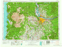
~ Vancouver WA topo map, 1:250000 scale, 1 X 2 Degree, Historical, 1964
Vancouver, Washington, USGS topographic map dated 1964.
Includes geographic coordinates (latitude and longitude). This topographic map is suitable for hiking, camping, and exploring, or framing it as a wall map.
Printed on-demand using high resolution imagery, on heavy weight and acid free paper, or alternatively on a variety of synthetic materials.
Topos available on paper, Waterproof, Poly, or Tyvek. Usually shipping rolled, unless combined with other folded maps in one order.
- Product Number: USGS-5689716
- Free digital map download (high-resolution, GeoPDF): Vancouver, Washington (file size: 24 MB)
- Map Size: please refer to the dimensions of the GeoPDF map above
- Weight (paper map): ca. 55 grams
- Map Type: POD USGS Topographic Map
- Map Series: HTMC
- Map Verison: Historical
- Cell ID: 396049
- Scan ID: 244445
- Woodland Tint: Yes
- Field Check Year: 1958
- Datum: Unstated
- Map Projection: Transverse Mercator
- Map published by United States Army Corps of Engineers
- Map published by United States Army
- Map Language: English
- Scanner Resolution: 600 dpi
- Map Cell Name: Vancouver
- Grid size: 1 X 2 Degree
- Date on map: 1964
- Map Scale: 1:250000
- Geographical region: Washington, United States
Neighboring Maps:
All neighboring USGS topo maps are available for sale online at a variety of scales.
Spatial coverage:
Topo map Vancouver, Washington, covers the geographical area associated the following places:
- Grand Ronde Agency - Mill Plain - Twelvemile Corner - Kellogg Park - Marlene Village - Dodson - Sandy - Portland - Treharne - Marquam - Jennings Lodge - Perrydale - Woodland - Hopewell - Scotts Mills - Central Point - Scotton Corner - Currinsville - Hazel Green - Clear Creek - Necanicum (historical) - Westimber (historical) - Neotsu - Blooming - Saint John - Dunthorpe - Ardenwald - Mount Vista - Brooks - Centerville (historical) - Bethel - Spitzenberg - Multnomah - Maywood Park - Rural Dell - Dundee - Marquam Hill - Barberton - Good Hope - Oak Hills - Pioneer - Buell - Ballston - Willamette - Burlingame - Christie (historical) - Norwood - West Saint Helens - Tillamook - Amboy - Springbrook - Moulton - Vernonia - Cannon Beach - Faloma - Reedville - Manhattan Beach - Hemlock - Logan - Lakewood - Damascus Heights - Wilkesboro - Oak Grove - Sara - Cruzatt - Sunnyside - Cherry Grove - Woodstock - Crawford - Midway - Denver (historical) - Alameda - Butte Creek (historical) - Union - Estacada - Vancouver - Otis - Pittsburg - Burlington - Bissell - Roads End - Tolovana Park - Yankton - South Portland (historical) - Cook - West Pioneer - Lents - Cloverdale - Tigard - Rex - Woodburn - Rosemont - Holbrook - Champoeg - South Lake Oswego - Caples - Saltair (historical) - Chapman - Corbett - Nenamusa (historical)
- Map Area ID: AREA4645-124.0833333-122
- Northwest corner Lat/Long code: USGSNW46-124.0833333
- Northeast corner Lat/Long code: USGSNE46-122
- Southwest corner Lat/Long code: USGSSW45-124.0833333
- Southeast corner Lat/Long code: USGSSE45-122
- Northern map edge Latitude: 46
- Southern map edge Latitude: 45
- Western map edge Longitude: -124.0833333
- Eastern map edge Longitude: -122