
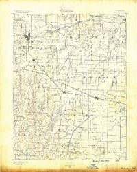
~ Moberly MO topo map, 1:125000 scale, 30 X 30 Minute, Historical, 1890
Moberly, Missouri, USGS topographic map dated 1890.
Includes geographic coordinates (latitude and longitude). This topographic map is suitable for hiking, camping, and exploring, or framing it as a wall map.
Printed on-demand using high resolution imagery, on heavy weight and acid free paper, or alternatively on a variety of synthetic materials.
Topos available on paper, Waterproof, Poly, or Tyvek. Usually shipping rolled, unless combined with other folded maps in one order.
- Product Number: USGS-8618566
- Free digital map download (high-resolution, GeoPDF): Moberly, Missouri (file size: 6 MB)
- Map Size: please refer to the dimensions of the GeoPDF map above
- Weight (paper map): ca. 55 grams
- Map Type: POD USGS Topographic Map
- Map Series: HTMC
- Map Verison: Historical
- Cell ID: 66072
- Scan ID: 325520
- Survey Year: 1887
- Datum: Unstated
- Map Projection: Unstated
- Map published by United States Geological Survey
- Map Language: English
- Scanner Resolution: 600 dpi
- Map Cell Name: Moberly
- Grid size: 30 X 30 Minute
- Date on map: 1890
- Map Scale: 1:125000
- Geographical region: Missouri, United States
Neighboring Maps:
All neighboring USGS topo maps are available for sale online at a variety of scales.
Spatial coverage:
Topo map Moberly, Missouri, covers the geographical area associated the following places:
- Centralia - Everett (historical) - Ryder - Madison - Minnie - Moberly - Switzler - Browns - Harkes - Germantown (historical) - Bourbon - Larrabee - Petersburg (historical) - Persia (historical) - Perche (historical) - Urbandale - Points (historical) - Middle Grove - Sturgeon - Hallsville - Milton - Murry - Prathersville - Hinton - Harrisburg - Hatton - Stephens - Saling - Tulip - Lebanon (historical) - Stapletown (historical) - Rowena - Evansville - Rileysburg - Clark - Lexington (historical) - Youngers - Middleton - Rucker - Fowkes - Woodlandville - Holliday - Kimberly - Paris - Renick - Riggs
- Map Area ID: AREA39.539-92.5-92
- Northwest corner Lat/Long code: USGSNW39.5-92.5
- Northeast corner Lat/Long code: USGSNE39.5-92
- Southwest corner Lat/Long code: USGSSW39-92.5
- Southeast corner Lat/Long code: USGSSE39-92
- Northern map edge Latitude: 39.5
- Southern map edge Latitude: 39
- Western map edge Longitude: -92.5
- Eastern map edge Longitude: -92


