
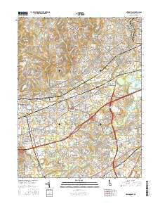
~ Newark East DE topo map, 1:24000 scale, 7.5 X 7.5 Minute, 2016
Newark East, Delaware, USGS topographic map dated 2016.
Includes geographic coordinates (latitude and longitude). This topographic map is suitable for hiking, camping, and exploring, or framing it as a wall map.
Printed on-demand using high resolution imagery, on heavy weight and acid free paper, or alternatively on a variety of synthetic materials.
Topos available on paper, Waterproof, Poly, or Tyvek. Usually shipping rolled, unless combined with other folded maps in one order.
- Product Number: USGS-8551524
- Free digital map download (high-resolution, GeoPDF): Newark East, Delaware (file size: 30 MB)
- Map Size: please refer to the dimensions of the GeoPDF map above
- Weight (paper map): ca. 55 grams
- Map Type: POD USGS Topographic Map
- Map Series: US Topo
- Map Verison: Current
- Cell ID: 31899
- Datum: North American Datum of 1983
- Map Projection: Transverse Mercator
- Map Cell Name: Newark East
- Grid size: 7.5 X 7.5 Minute
- Date on map: 2016
- Map Scale: 1:24000
- Geographical region: Delaware, United States
Neighboring Maps:
All neighboring USGS topo maps are available for sale online at a variety of scales.
Spatial coverage:
Topo map Newark East, Delaware, covers the geographical area associated the following places:
- Sherwood Park - Timber Ridge - Milltown - Oak Hollow - Robscott Manor - Cranston Heights - Capital Trail Farms - Piermont Woods - Iron Hills Apartments - Eastburn Farms - Harmony - Red Mills Farms - Pleasantville - Brookside - Stanton - Albertson - Limestone Gardene - Raintree Village - Chapel Hill - Christiana Landing - Milford Crossroads - Eastburn Heights - Sherwood Forest - Sheffield Manor - Pleasant Hill - Skyline Ridge - Cherokee Woods - Pencader - Stage Road Development - Green Valley - Ogletown - Corner Ketch - Princeton Wood II - Choate - Cedar Farms - Limestone Acres - Weatherhill Farms - Linden Green Apartment - Glenville - Heritage - Todd Estates - Concord Towers - Delaplane Manor - Chestnut Hill Estates - Village of Cantebury - Albertson Park - Marshallton Heights II - Heritage Farms - The Villa - Klair Estate - Hyde Park - Lumbrook - Pine Swamp Corner - Fairway Falls - Fox Woods - Linden Heath - Marshallton - Stones Throw - The Pines of Pike Creek - Glendale - Pepper Ridge - Greenbank - Wilson - Heather Woods - Glen Berne Estates - Stratford - Sycamore Gardens - Redmont - Cedars Knoll - Fairwinds - Whilton - Skyline Crest - Arundel - Roseville Park - Dunlinden Acres - Varlano - Melanie - Woodcreek - Carousel Knoll - Marshallton Green - Newark - Christiana Village - Pennock - Elmwood - Wellington Woods - Milford Meadows - Marydale - Kiamensi - Old Mill Manor - Windy Hills - Tybrook - Belford Manor - Newark Oaks - Kirkwood Gardens - Scottfield - Victoria Woods - Foxfire - The Woods - Albion - Grendon Farms
- Map Area ID: AREA39.7539.625-75.75-75.625
- Northwest corner Lat/Long code: USGSNW39.75-75.75
- Northeast corner Lat/Long code: USGSNE39.75-75.625
- Southwest corner Lat/Long code: USGSSW39.625-75.75
- Southeast corner Lat/Long code: USGSSE39.625-75.625
- Northern map edge Latitude: 39.75
- Southern map edge Latitude: 39.625
- Western map edge Longitude: -75.75
- Eastern map edge Longitude: -75.625


