
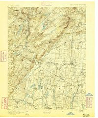
~ Ramapo NY topo map, 1:62500 scale, 15 X 15 Minute, Historical, 1891
Ramapo, New York, USGS topographic map dated 1891.
Includes geographic coordinates (latitude and longitude). This topographic map is suitable for hiking, camping, and exploring, or framing it as a wall map.
Printed on-demand using high resolution imagery, on heavy weight and acid free paper, or alternatively on a variety of synthetic materials.
Topos available on paper, Waterproof, Poly, or Tyvek. Usually shipping rolled, unless combined with other folded maps in one order.
- Product Number: USGS-8527086
- Free digital map download (high-resolution, GeoPDF): Ramapo, New York (file size: 8 MB)
- Map Size: please refer to the dimensions of the GeoPDF map above
- Weight (paper map): ca. 55 grams
- Map Type: POD USGS Topographic Map
- Map Series: HTMC
- Map Verison: Historical
- Cell ID: 61429
- Scan ID: 148251
- Survey Year: 1888
- Datum: Unstated
- Map Projection: Unstated
- Map published by United States Geological Survey
- Map Language: English
- Scanner Resolution: 600 dpi
- Map Cell Name: Ramapo
- Grid size: 15 X 15 Minute
- Date on map: 1891
- Map Scale: 1:62500
- Geographical region: New York, United States
Neighboring Maps:
All neighboring USGS topo maps are available for sale online at a variety of scales.
Spatial coverage:
Topo map Ramapo, New York, covers the geographical area associated the following places:
- Mazzaleone Park - Tuxedo Park - Pomona - Upper Saddle River - Woodcliff Lake - Mount Ivy - Eagle Valley - Saddle River - Ringwood - New Hempstead - Hillsdale Manor - Spring Valley - Southfields - Monsey - Montebello - Chestnut Ridge - Willow Grove - Mount Pleasant - Ackermans Mills - Park Ridge - Mahwah - Suffern Park - Upper Montvale - Rivervale - Viola - Crystal Lake - Kaser - Cedar Flats - Villa Marie Claire - Waldwick - Pulis Mills - Masonicus - Campgaw - Suffern - Hillburn - Chestnut Ridge - Oakbrook - New City Park - Airmont - Cragmere Park - Allendale - Wesley Hills - Parkway Mobile Home Park - Felters Corners - Sloatsburg - Hillcrest - Ladentown - Antrim - Thiells - Pomona Heights - Tallman - Skylands - Quaker Park - New Hempstead - Bogerts Ranch Estates - Happy Valley - Sterlington - Ramsey - Montvale - Hillsdale - Spring Valley Village - Camp Hill - West Mahwah - Fountain Head Mobile Home Park - Ramapo - Pearl River - Wyckoff - Summit Park - Clinton Woods - Franklin Lakes - Nanuet - New Square - Fardale - Darlington - Laurel Ridge - Upper Montvale - Ferdinands Mills
- Map Area ID: AREA41.2541-74.25-74
- Northwest corner Lat/Long code: USGSNW41.25-74.25
- Northeast corner Lat/Long code: USGSNE41.25-74
- Southwest corner Lat/Long code: USGSSW41-74.25
- Southeast corner Lat/Long code: USGSSE41-74
- Northern map edge Latitude: 41.25
- Southern map edge Latitude: 41
- Western map edge Longitude: -74.25
- Eastern map edge Longitude: -74


