
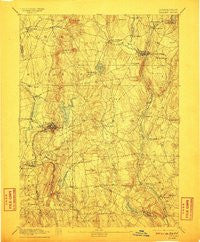
~ Tolland CT topo map, 1:62500 scale, 15 X 15 Minute, Historical, 1892, updated 1911
Tolland, Connecticut, USGS topographic map dated 1892.
Includes geographic coordinates (latitude and longitude). This topographic map is suitable for hiking, camping, and exploring, or framing it as a wall map.
Printed on-demand using high resolution imagery, on heavy weight and acid free paper, or alternatively on a variety of synthetic materials.
Topos available on paper, Waterproof, Poly, or Tyvek. Usually shipping rolled, unless combined with other folded maps in one order.
- Product Number: USGS-8506962
- Free digital map download (high-resolution, GeoPDF): Tolland, Connecticut (file size: 9 MB)
- Map Size: please refer to the dimensions of the GeoPDF map above
- Weight (paper map): ca. 55 grams
- Map Type: POD USGS Topographic Map
- Map Series: HTMC
- Map Verison: Historical
- Cell ID: 63611
- Scan ID: 331181
- Imprint Year: 1911
- Survey Year: 1890
- Datum: Unstated
- Map Projection: Unstated
- Map published by United States Geological Survey
- Map Language: English
- Scanner Resolution: 600 dpi
- Map Cell Name: Tolland
- Grid size: 15 X 15 Minute
- Date on map: 1892
- Map Scale: 1:62500
- Geographical region: Connecticut, United States
Neighboring Maps:
All neighboring USGS topo maps are available for sale online at a variety of scales.
Spatial coverage:
Topo map Tolland, Connecticut, covers the geographical area associated the following places:
- Highland Park - Orcutts - Rockville - Mansfield Four Corners - Lydallville - Merrow - South Coventry - Coventry - Coventry Lake - Windermere - North Coventry - Staffordville - West Willington - Somersville - Mansfield Depot - Vernon Center - Ellithorpe - Bolton - South Willington - Somers - Stafford - Crystal Lake - Lake View Terrace - Vernon - Ellington - Quarryville - Tolland - Eagleville - West Stafford - Stafford Springs - Hydeville - Willington Hill
- Map Area ID: AREA4241.75-72.5-72.25
- Northwest corner Lat/Long code: USGSNW42-72.5
- Northeast corner Lat/Long code: USGSNE42-72.25
- Southwest corner Lat/Long code: USGSSW41.75-72.5
- Southeast corner Lat/Long code: USGSSE41.75-72.25
- Northern map edge Latitude: 42
- Southern map edge Latitude: 41.75
- Western map edge Longitude: -72.5
- Eastern map edge Longitude: -72.25


