
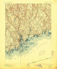
~ Norwalk CT topo map, 1:62500 scale, 15 X 15 Minute, Historical, 1893, updated 1913
Norwalk, Connecticut, USGS topographic map dated 1893.
Includes geographic coordinates (latitude and longitude). This topographic map is suitable for hiking, camping, and exploring, or framing it as a wall map.
Printed on-demand using high resolution imagery, on heavy weight and acid free paper, or alternatively on a variety of synthetic materials.
Topos available on paper, Waterproof, Poly, or Tyvek. Usually shipping rolled, unless combined with other folded maps in one order.
- Product Number: USGS-8506938
- Free digital map download (high-resolution, GeoPDF): Norwalk, Connecticut (file size: 8 MB)
- Map Size: please refer to the dimensions of the GeoPDF map above
- Weight (paper map): ca. 55 grams
- Map Type: POD USGS Topographic Map
- Map Series: HTMC
- Map Verison: Historical
- Cell ID: 60365
- Scan ID: 331132
- Imprint Year: 1913
- Survey Year: 1890
- Datum: Unstated
- Map Projection: Unstated
- Map published by United States Geological Survey
- Map Language: English
- Scanner Resolution: 600 dpi
- Map Cell Name: Norwalk
- Grid size: 15 X 15 Minute
- Date on map: 1893
- Map Scale: 1:62500
- Geographical region: Connecticut, United States
Neighboring Maps:
All neighboring USGS topo maps are available for sale online at a variety of scales.
Spatial coverage:
Topo map Norwalk, Connecticut, covers the geographical area associated the following places:
- Aspetuck - Harborview - Richards Corner - Rowayton - Owenoke - Godfrey Corner - Cannondale - Fairfield - South Norwalk - Weston - Saugatuck - Hale Court - Compo - Greenfield Hill - Southport - North Wilton - Murray - New Canaan - Noroton - Winnipauk - Talmadge Hill - Winnipauk Village - Shorehaven - Wilton - Silvermine - Plattsville - Saugatuck Shores - West Norwalk - Norwalk - Daniels Mill - East Norwalk - Cranbury - Hockanum Park (historical) - Coley Town - Noroton Heights - Gilbert Corners - Mill Plain - Darien - Lyons Plain - Round Beach - Westport - Tokeneke - South Wilton - Greens Farms
- Map Area ID: AREA41.2541-73.5-73.25
- Northwest corner Lat/Long code: USGSNW41.25-73.5
- Northeast corner Lat/Long code: USGSNE41.25-73.25
- Southwest corner Lat/Long code: USGSSW41-73.5
- Southeast corner Lat/Long code: USGSSE41-73.25
- Northern map edge Latitude: 41.25
- Southern map edge Latitude: 41
- Western map edge Longitude: -73.5
- Eastern map edge Longitude: -73.25


