
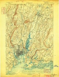
~ New Haven CT topo map, 1:62500 scale, 15 X 15 Minute, Historical, 1892, updated 1902
New Haven, Connecticut, USGS topographic map dated 1892.
Includes geographic coordinates (latitude and longitude). This topographic map is suitable for hiking, camping, and exploring, or framing it as a wall map.
Printed on-demand using high resolution imagery, on heavy weight and acid free paper, or alternatively on a variety of synthetic materials.
Topos available on paper, Waterproof, Poly, or Tyvek. Usually shipping rolled, unless combined with other folded maps in one order.
- Product Number: USGS-8506888
- Free digital map download (high-resolution, GeoPDF): New Haven, Connecticut (file size: 11 MB)
- Map Size: please refer to the dimensions of the GeoPDF map above
- Weight (paper map): ca. 55 grams
- Map Type: POD USGS Topographic Map
- Map Series: HTMC
- Map Verison: Historical
- Cell ID: 58364
- Scan ID: 331088
- Imprint Year: 1902
- Survey Year: 1890
- Datum: Unstated
- Map Projection: Unstated
- Map published by United States Geological Survey
- Keywords: Overedge
- Map Language: English
- Scanner Resolution: 600 dpi
- Map Cell Name: New Haven
- Grid size: 15 X 15 Minute
- Date on map: 1892
- Map Scale: 1:62500
- Geographical region: Connecticut, United States
Neighboring Maps:
All neighboring USGS topo maps are available for sale online at a variety of scales.
Spatial coverage:
Topo map New Haven, Connecticut, covers the geographical area associated the following places:
- North Haven - Clintonville - Liberia (historical) - Momauguin - New Haven - Davidsons Corner - Highwood (historical) - West Haven - Mount Carmel - Augerville - Centerville - Fair Haven - Montowese - Sea Bluff - Barnesville - New Guinea (historical) - City Point - West Hills - Double Beach - Millbrook - East Haven - Spring Glen - Brooksvale - Armoryville (historical) - Short Beach - Quinnipiac - North Branford - Fair Haven East - Meadowbrook - Ives Corner - Mountaincrest - Strathmore Woods - Fernwood Estates - Brightview - Foxon - Totoket - Platts Knoll - Hemingway Town (historical) - Westville - New Halville - Hamden - Indian Neck - Pine Orchard - North Haven Bridge - Northford - Cheshire - Mount Carmel Center - Yalesville - East Wallingford - Branford - Brewsterville (historical) - Bethany - Slineyville (historical) - Richards Corner - Bethany Wood - Branford Hills - Morris Cove - Whitneyville - Savin Rock - Thompson Corner (historical) - Raynham - Allingtown - Wallingford
- Map Area ID: AREA41.541.25-73-72.75
- Northwest corner Lat/Long code: USGSNW41.5-73
- Northeast corner Lat/Long code: USGSNE41.5-72.75
- Southwest corner Lat/Long code: USGSSW41.25-73
- Southeast corner Lat/Long code: USGSSE41.25-72.75
- Northern map edge Latitude: 41.5
- Southern map edge Latitude: 41.25
- Western map edge Longitude: -73
- Eastern map edge Longitude: -72.75


