
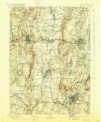
~ Meriden CT topo map, 1:62500 scale, 15 X 15 Minute, Historical, 1893, updated 1928
Meriden, Connecticut, USGS topographic map dated 1893.
Includes geographic coordinates (latitude and longitude). This topographic map is suitable for hiking, camping, and exploring, or framing it as a wall map.
Printed on-demand using high resolution imagery, on heavy weight and acid free paper, or alternatively on a variety of synthetic materials.
Topos available on paper, Waterproof, Poly, or Tyvek. Usually shipping rolled, unless combined with other folded maps in one order.
- Product Number: USGS-8506844
- Free digital map download (high-resolution, GeoPDF): Meriden, Connecticut (file size: 9 MB)
- Map Size: please refer to the dimensions of the GeoPDF map above
- Weight (paper map): ca. 55 grams
- Map Type: POD USGS Topographic Map
- Map Series: HTMC
- Map Verison: Historical
- Cell ID: 72747
- Scan ID: 331064
- Imprint Year: 1928
- Survey Year: 1890
- Datum: NAD
- Map Projection: Polyconic
- Map published by United States Geological Survey
- Map Language: English
- Scanner Resolution: 600 dpi
- Map Cell Name: Meriden
- Grid size: 15 X 15 Minute
- Date on map: 1893
- Map Scale: 1:62500
- Geographical region: Connecticut, United States
Neighboring Maps:
All neighboring USGS topo maps are available for sale online at a variety of scales.
Spatial coverage:
Topo map Meriden, Connecticut, covers the geographical area associated the following places:
- West District - Farmington Station - Fox Hollow - Mixville - Meriden - Pratts Corner - Pinnacle Heights Housing - Bishops Corner - River Glen - Turkey Hill - Cheshire Street (historical) - Pondside - Bensted Corner - Woodtick - East Plymouth - Tracy - East Farms - Milldale - Autumn HIll - Pequabuck - Bristol - Stillmans Corner - Whigville - East Meriden - Corbin Heights Housing - East Farmington Heights - Lamson Corner - New Britain - Plantsville - South Meriden - Liberty Mobile Home Park - Southington - Prospect - Edgewood - Marion - Oakland Gardens - East Bristol - Mount Pleasant Housing - Deaconwood - Forestville - Miller Memorial Community - West Cheshire - Farmington - Honeypot Glen - Kensington - Oakland Gardens - North End - Wolcott - Fox Hollow - Plainville - Allentown
- Map Area ID: AREA41.7541.5-73-72.75
- Northwest corner Lat/Long code: USGSNW41.75-73
- Northeast corner Lat/Long code: USGSNE41.75-72.75
- Southwest corner Lat/Long code: USGSSW41.5-73
- Southeast corner Lat/Long code: USGSSE41.5-72.75
- Northern map edge Latitude: 41.75
- Southern map edge Latitude: 41.5
- Western map edge Longitude: -73
- Eastern map edge Longitude: -72.75


