
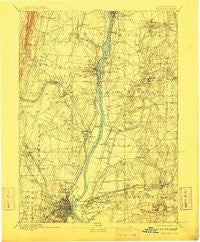
~ Hartford CT topo map, 1:62500 scale, 15 X 15 Minute, Historical, 1892, updated 1910
Hartford, Connecticut, USGS topographic map dated 1892.
Includes geographic coordinates (latitude and longitude). This topographic map is suitable for hiking, camping, and exploring, or framing it as a wall map.
Printed on-demand using high resolution imagery, on heavy weight and acid free paper, or alternatively on a variety of synthetic materials.
Topos available on paper, Waterproof, Poly, or Tyvek. Usually shipping rolled, unless combined with other folded maps in one order.
- Product Number: USGS-8506826
- Free digital map download (high-resolution, GeoPDF): Hartford, Connecticut (file size: 7 MB)
- Map Size: please refer to the dimensions of the GeoPDF map above
- Weight (paper map): ca. 55 grams
- Map Type: POD USGS Topographic Map
- Map Series: HTMC
- Map Verison: Historical
- Cell ID: 55121
- Scan ID: 331052
- Imprint Year: 1910
- Survey Year: 1889
- Datum: Unstated
- Map Projection: Unstated
- Map published by United States Geological Survey
- Map Language: English
- Scanner Resolution: 600 dpi
- Map Cell Name: Hartford
- Grid size: 15 X 15 Minute
- Date on map: 1892
- Map Scale: 1:62500
- Geographical region: Connecticut, United States
Neighboring Maps:
All neighboring USGS topo maps are available for sale online at a variety of scales.
Spatial coverage:
Topo map Hartford, Connecticut, covers the geographical area associated the following places:
- Windsor Locks - Warehouse Point - Coachlight Village - Melrose - East Granby - Wilson - Talcottville - South Windsor - Manchester - Burnside - Green Manor Village - Burnham - East Hartford - Birchwood - Scitico - East Windsor Hill - Childrens Village of the Hartford Orphan Asylum - Higley Village - Bull Run Corner - Cottage Grove - West Suffield - Mayberry Village - Broad Brook - Hayden - Wapping - Southwood Acres - Manchester Green - Spring Village - Scantic - Rainbow - Hazardville - Parkville - Kings Corner - Oakland - Thralltown - Flax Hill Elderly Housing - Wapping Mews Elderly Housing - Fernridge Place - Farnhams - Windsor - Buckland - Spoonville (historical) - Blue Hills - Enfield - Breakneck - Spoonville - Oxford Village - Smith Tower Housing - North Bloomfield - Stowe Village Housing Project - Poquonock - Hilliardville - Bloomfield - West Hartford - Suffield Depot - Dutch Point Colony - Hartford - Suffield - Windsorville - Mill Pond Village - Thompsonville - Tudor Village - West Hill
- Map Area ID: AREA4241.75-72.75-72.5
- Northwest corner Lat/Long code: USGSNW42-72.75
- Northeast corner Lat/Long code: USGSNE42-72.5
- Southwest corner Lat/Long code: USGSSW41.75-72.75
- Southeast corner Lat/Long code: USGSSE41.75-72.5
- Northern map edge Latitude: 42
- Southern map edge Latitude: 41.75
- Western map edge Longitude: -72.75
- Eastern map edge Longitude: -72.5


