
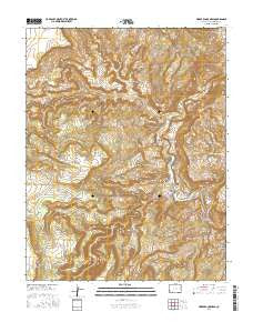
~ Horse Range Mesa CO topo map, 1:24000 scale, 7.5 X 7.5 Minute, 2016
Horse Range Mesa, Colorado, USGS topographic map dated 2016.
Includes geographic coordinates (latitude and longitude). This topographic map is suitable for hiking, camping, and exploring, or framing it as a wall map.
Printed on-demand using high resolution imagery, on heavy weight and acid free paper, or alternatively on a variety of synthetic materials.
Topos available on paper, Waterproof, Poly, or Tyvek. Usually shipping rolled, unless combined with other folded maps in one order.
- Product Number: USGS-8371482
- Free digital map download (high-resolution, GeoPDF): Horse Range Mesa, Colorado (file size: 32 MB)
- Map Size: please refer to the dimensions of the GeoPDF map above
- Weight (paper map): ca. 55 grams
- Map Type: POD USGS Topographic Map
- Map Series: US Topo
- Map Verison: Current
- Cell ID: 21091
- Datum: North American Datum of 1983
- Map Projection: Transverse Mercator
- Map Cell Name: Horse Range Mesa
- Grid size: 7.5 X 7.5 Minute
- Date on map: 2016
- Map Scale: 1:24000
- Geographical region: Colorado, United States
Neighboring Maps:
All neighboring USGS topo maps are available for sale online at a variety of scales.
Spatial coverage:
Topo map Horse Range Mesa, Colorado, covers the geographical area associated the following places:
- Burro Mine - Bush Canyon - Cacti Number Two Mine - Charles T Mines - India Mine - Herbert Mine - Middle Group Mines - Parrot Mines - Michael Bray Mine - East Summit - Radium Number Thirty Mine - Painted Rock Mine - San Miguel Mine - Alice Number Four Mine - Radium Number Two Mine - Rainbow Mine - Bean Patch Mine - Otera Incline Mine - Lucky B Mine - North Slope Two Mine - Ellison Mine - Radium Number Fifteen Mine - Summit Group Mine - Sears Number One Mine - Lower Group Mines - Burro Tunnel Mine - Big S Mine - Black Fox Mine - Northern Light Mine - Cone Number Six Mine - Sunnyside Mine - Charlotte Number One Mine - Firefly Mine - Slick Rock - Grubstake Mine - Colorado Cat Mine - Corral Draw - Skidmore Mine - Bottom Canyon Mine - Little Marie Mine - Mortgage Lifter Mine - S.B. Number Nine Mine - Stevens Canyon - Steamboat Hill - Pinto Mine - Cougar Mine - Cougar Canyon - Radium Number Thirteen Mine - Uintah Adit Mine - Black Bird Mine - Prospectors Fortune Mine - Haymaker-Sunset Mine - Robbins Mine - Deluxe Mine - Radium Number Nine Mine - Grassy Hills - Middle Yolande Mine - Dragon Claims Mine - Last Chance Mine - Upper Group Mines - Horse Range Mesa - Jackie L Mine - Lee Mock Mine - Memphis Mine - Horse Range Spring - Burro Canyon - Yellowbird Mine - Summit Fraction Mine - Katydid Mine - Georgetown Mine - Veta Glad Mine - Hawkeye Mine - Radium Group Mines - Slick Rock Bridge - Little Mariel Mine - Bean Mine - Letty Jones Mine - Tailholt Mines - Hanks Pocket - Grass Flat Mine - Sesmo Mine - Martha Sue Mine - Sunrise Mine - Lee C Mine - Summit Point - Helen Number Three Mine - Radium Number Twenty-seven Mine - Slick Rock Hill - Cape Horn - Jackie Walls Mine - Brighton Mine - Summit Canyon - Lower Section Mine - Midnight Mine - Bean Mine - Veta Mad Number Two Mine - Alice Mine - Burro Number Three Mine - Ike Number Three Mine - Tommy White Mine
- Map Area ID: AREA38.12538-109-108.875
- Northwest corner Lat/Long code: USGSNW38.125-109
- Northeast corner Lat/Long code: USGSNE38.125-108.875
- Southwest corner Lat/Long code: USGSSW38-109
- Southeast corner Lat/Long code: USGSSE38-108.875
- Northern map edge Latitude: 38.125
- Southern map edge Latitude: 38
- Western map edge Longitude: -109
- Eastern map edge Longitude: -108.875


