
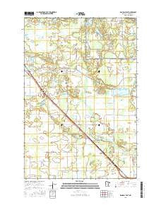
~ Randall East MN topo map, 1:24000 scale, 7.5 X 7.5 Minute, 2016
Randall East, Minnesota, USGS topographic map dated 2016.
Includes geographic coordinates (latitude and longitude). This topographic map is suitable for hiking, camping, and exploring, or framing it as a wall map.
Printed on-demand using high resolution imagery, on heavy weight and acid free paper, or alternatively on a variety of synthetic materials.
Topos available on paper, Waterproof, Poly, or Tyvek. Usually shipping rolled, unless combined with other folded maps in one order.
- Product Number: USGS-8227718
- Free digital map download (high-resolution, GeoPDF): Randall East, Minnesota (file size: 23 MB)
- Map Size: please refer to the dimensions of the GeoPDF map above
- Weight (paper map): ca. 55 grams
- Map Type: POD USGS Topographic Map
- Map Series: US Topo
- Map Verison: Current
- Cell ID: 71341
- Datum: North American Datum of 1983
- Map Projection: Transverse Mercator
- Map Cell Name: Randall East
- Grid size: 7.5 X 7.5 Minute
- Date on map: 2016
- Map Scale: 1:24000
- Geographical region: Minnesota, United States
Neighboring Maps:
All neighboring USGS topo maps are available for sale online at a variety of scales.
Spatial coverage:
Topo map Randall East, Minnesota, covers the geographical area associated the following places:
- Doctor S G Knight Elementary School - Saint James Cemetery - Fish Lake Cemetery - School Number 57 - School Number 35 - Thirty-Seven Acres Resort and Campground - Three Finger Lake - Randall Fire Department - Johnson Lake - Immanuel Church - Dale Lake - Immanuel Lutheran Cemetery - Darling Switch - Saint James Catholic Church - School Number 33 - Township of Darling - Green Prairie Fish Lake - Ferrell Lake - Kraft Lake - Darling Post Office (historical) - South Branch Little Elk River - Goose Lake - Old Darling Mission Cemetery - School Number 37 - School Number 74
- Map Area ID: AREA46.12546-94.5-94.375
- Northwest corner Lat/Long code: USGSNW46.125-94.5
- Northeast corner Lat/Long code: USGSNE46.125-94.375
- Southwest corner Lat/Long code: USGSSW46-94.5
- Southeast corner Lat/Long code: USGSSE46-94.375
- Northern map edge Latitude: 46.125
- Southern map edge Latitude: 46
- Western map edge Longitude: -94.5
- Eastern map edge Longitude: -94.375


