
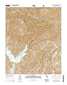
~ Warm Springs Mountain CA topo map, 1:24000 scale, 7.5 X 7.5 Minute, 2015
Warm Springs Mountain, California, USGS topographic map dated 2015.
Includes geographic coordinates (latitude and longitude). This topographic map is suitable for hiking, camping, and exploring, or framing it as a wall map.
Printed on-demand using high resolution imagery, on heavy weight and acid free paper, or alternatively on a variety of synthetic materials.
Topos available on paper, Waterproof, Poly, or Tyvek. Usually shipping rolled, unless combined with other folded maps in one order.
- Product Number: USGS-7992371
- Free digital map download (high-resolution, GeoPDF): Warm Springs Mountain, California (file size: 27 MB)
- Map Size: please refer to the dimensions of the GeoPDF map above
- Weight (paper map): ca. 55 grams
- Map Type: POD USGS Topographic Map
- Map Series: US Topo
- Map Verison: Current
- Cell ID: 47485
- Datum: North American Datum of 1983
- Map Projection: Transverse Mercator
- Map Cell Name: Warm Springs Mountain
- Grid size: 7.5 X 7.5 Minute
- Date on map: 2015
- Map Scale: 1:24000
- Geographical region: California, United States
Neighboring Maps:
All neighboring USGS topo maps are available for sale online at a variety of scales.
Spatial coverage:
Topo map Warm Springs Mountain, California, covers the geographical area associated the following places:
- Castaic Lake - South Tule Canyon - Necktie Canyon - Rattlesnake Canyon - Drinkwater Canyon - Kleine Canyon - Los Angeles Aqueduct - Drinkwater Flat - Daries Ranch (historical) - United States Forest Service Angeles National Forest Station - San Francisquito Canyon - Dry Gulch - Prospect Canyon - Dry Target Shooting Area - Newhall Division - Elizabeth Lake Canyon Campground - Elizabeth Lake Guard Station - Warm Springs Canyon - Castaic Lake Dam - Elizabeth Lake Canyon - Ruby Spring - Warm Springs Fish Canyon Truck Trail - Warm Springs Necktie Trail - Ruby Canyon - Red Mountain - Drinkwater Reservoir - Castaic Tunnel Number One - Canyon Christian Camp - Warm Springs Mountain - Grasshopper Canyon - Bee School (historical) - Tule Target Shooting Area - Warm Springs Camp - Baal Point Picnic Area - Necktie Basin - Bitter Canyon - Castaic Valley Siphon - San Francisquito Powerhouse Number Two - Warm Springs Trail - Warm Springs Divide Truck Trail - Tule Canyon - Prospect Campground - Castaic Dam Heliport - Drinkwater 6-016 Dam - Ruby Clearwater Truck Trail - Castaic Lake State Recreation Area
- Map Area ID: AREA34.62534.5-118.625-118.5
- Northwest corner Lat/Long code: USGSNW34.625-118.625
- Northeast corner Lat/Long code: USGSNE34.625-118.5
- Southwest corner Lat/Long code: USGSSW34.5-118.625
- Southeast corner Lat/Long code: USGSSE34.5-118.5
- Northern map edge Latitude: 34.625
- Southern map edge Latitude: 34.5
- Western map edge Longitude: -118.625
- Eastern map edge Longitude: -118.5


