
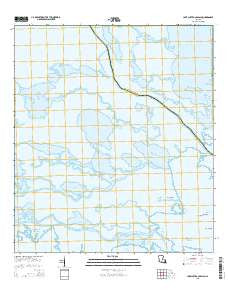
~ Lake Cuatro Caballo LA topo map, 1:24000 scale, 7.5 X 7.5 Minute, 2015
Lake Cuatro Caballo, Louisiana, USGS topographic map dated 2015.
Includes geographic coordinates (latitude and longitude). This topographic map is suitable for hiking, camping, and exploring, or framing it as a wall map.
Printed on-demand using high resolution imagery, on heavy weight and acid free paper, or alternatively on a variety of synthetic materials.
Topos available on paper, Waterproof, Poly, or Tyvek. Usually shipping rolled, unless combined with other folded maps in one order.
- Product Number: USGS-7974237
- Free digital map download (high-resolution, GeoPDF): Lake Cuatro Caballo, Louisiana (file size: 21 MB)
- Map Size: please refer to the dimensions of the GeoPDF map above
- Weight (paper map): ca. 55 grams
- Map Type: POD USGS Topographic Map
- Map Series: US Topo
- Map Verison: Current
- Cell ID: 24404
- Datum: North American Datum of 1983
- Map Projection: Transverse Mercator
- Map Cell Name: Lake Cuatro Caballo
- Grid size: 7.5 X 7.5 Minute
- Date on map: 2015
- Map Scale: 1:24000
- Geographical region: Louisiana, United States
Neighboring Maps:
All neighboring USGS topo maps are available for sale online at a variety of scales.
Spatial coverage:
Topo map Lake Cuatro Caballo, Louisiana, covers the geographical area associated the following places:
- Popcorn Bayou - Lost Flat Bayou - Bayou Zip - Adema Pond - Petain Lagoon - Little False River - Bayou Menard - Crooked Bayou - Lake Pato Caballo - Round Lake - Rat Bayou - Bayou Ponton - Polk and Dallas Bayou - Sister Bayou - Branville Bay - Bottle Bayou - Bayou Goudet - Lake Campo Pass - Lost Flat Bay - Sand Hill Bayou - Bayou Terre Aux Boeufs - Bayou Jean Louis Robin - Bayou Lingeo - Bay Shallow - Deer Island - Lake Cuatro Caballo - Bottle Lagoon - Lake Campo - Bayou Fon Gera - Daylight Bay - False River - Bay of River Aux Chenes - Pintail Flat - Flat Bayou - Deer Island Bayou - Crooked Bayou Gas Field - Lake John - Lake Jean Louis Robin
- Map Area ID: AREA29.7529.625-89.75-89.625
- Northwest corner Lat/Long code: USGSNW29.75-89.75
- Northeast corner Lat/Long code: USGSNE29.75-89.625
- Southwest corner Lat/Long code: USGSSW29.625-89.75
- Southeast corner Lat/Long code: USGSSE29.625-89.625
- Northern map edge Latitude: 29.75
- Southern map edge Latitude: 29.625
- Western map edge Longitude: -89.75
- Eastern map edge Longitude: -89.625


