
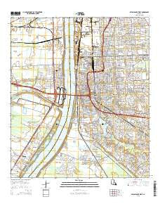
~ Baton Rouge West LA topo map, 1:24000 scale, 7.5 X 7.5 Minute, 2015
Baton Rouge West, Louisiana, USGS topographic map dated 2015.
Includes geographic coordinates (latitude and longitude). This topographic map is suitable for hiking, camping, and exploring, or framing it as a wall map.
Printed on-demand using high resolution imagery, on heavy weight and acid free paper, or alternatively on a variety of synthetic materials.
Topos available on paper, Waterproof, Poly, or Tyvek. Usually shipping rolled, unless combined with other folded maps in one order.
- Product Number: USGS-7971600
- Free digital map download (high-resolution, GeoPDF): Baton Rouge West, Louisiana (file size: 28 MB)
- Map Size: please refer to the dimensions of the GeoPDF map above
- Weight (paper map): ca. 55 grams
- Map Type: POD USGS Topographic Map
- Map Series: US Topo
- Map Verison: Current
- Cell ID: 2643
- Datum: North American Datum of 1983
- Map Projection: Transverse Mercator
- Map Cell Name: Baton Rouge West
- Grid size: 7.5 X 7.5 Minute
- Date on map: 2015
- Map Scale: 1:24000
- Geographical region: Louisiana, United States
Neighboring Maps:
All neighboring USGS topo maps are available for sale online at a variety of scales.
Spatial coverage:
Topo map Baton Rouge West, Louisiana, covers the geographical area associated the following places:
- Magnolia Terrace - Hyacinth Terrace - Hundred Oaks - Sweetbriar - Smiley Heights - Marwede - Highland Hills - Prescott Court - Beauregard Town - Greenville - Plantation Trace - Highland Road Estates - East Dayton - South Dayton - Cinclare - Heatherstone - Standard Heights - Eastland - Capitol View - University Gardens - Beaulieu - Zee Zee Gardens - Sunrise - Riverbend - Brusly Landing - Roppolo Villa - Magnolia Ridge - Meadow Lea - Glenmore - White Plains - College Park - Progress - Steele Place - Fairwoods - Istrouma - Walnut Hill - South Baton Rouge - Tigerland Acres - Capital Heights - Lukeville - New Dayton - Westdale Heights - Port Allen Landing - Swart - Moss Side Place - University South - Poplar Grove Plantation - Southdowns - Saint Gerald Park - Longwood Court - Highland Gardens - Port Allen - Lynn Place - College Drive Heights - Sharlo - Ardenwood - Nicholson Estates - Kenilworth - Baton Rouge - Woodstone Estates - Frisco (historical) - Concord Park - Antonio - B and K Mobile Park - McGrath Heights - Plantation Mobile Home Park - Magnolia Heights - Harwich - Concord Estates - Delmont Place - Baton Rouge Terrace - Bernard Terrace - Prescott Place - Melrose Place - Villa Ashley - Court Street Estates Mobile Home Park - Collegetown - Kleinert - University View - West Baton Rouge - Belfair - Dougherty Place - University Hills - Northdale - Belfort - Ogden Park - Cinclare Landing (historical) - Stafford Place - Moreland - Highland Park Heights - Pollard Estates - Brightside Park - Westdale Terrace - Howell Park Terrace - Belmont - North Highlands - College Hills - Dent Terrace - Lakecrest - Dayton
- Map Area ID: AREA30.530.375-91.25-91.125
- Northwest corner Lat/Long code: USGSNW30.5-91.25
- Northeast corner Lat/Long code: USGSNE30.5-91.125
- Southwest corner Lat/Long code: USGSSW30.375-91.25
- Southeast corner Lat/Long code: USGSSE30.375-91.125
- Northern map edge Latitude: 30.5
- Southern map edge Latitude: 30.375
- Western map edge Longitude: -91.25
- Eastern map edge Longitude: -91.125


