
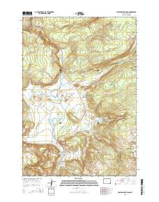
~ Lower Geyser Basin WY topo map, 1:24000 scale, 7.5 X 7.5 Minute, 2015
Lower Geyser Basin, Wyoming, USGS topographic map dated 2015.
Includes geographic coordinates (latitude and longitude). This topographic map is suitable for hiking, camping, and exploring, or framing it as a wall map.
Printed on-demand using high resolution imagery, on heavy weight and acid free paper, or alternatively on a variety of synthetic materials.
Topos available on paper, Waterproof, Poly, or Tyvek. Usually shipping rolled, unless combined with other folded maps in one order.
- Product Number: USGS-7860937
- Free digital map download (high-resolution, GeoPDF): Lower Geyser Basin, Wyoming (file size: 23 MB)
- Map Size: please refer to the dimensions of the GeoPDF map above
- Weight (paper map): ca. 55 grams
- Map Type: POD USGS Topographic Map
- Map Series: US Topo
- Map Verison: Current
- Cell ID: 26796
- Datum: North American Datum of 1983
- Map Projection: Transverse Mercator
- Map Cell Name: Lower Geyser Basin
- Grid size: 7.5 X 7.5 Minute
- Date on map: 2015
- Map Scale: 1:24000
- Geographical region: Wyoming, United States
Neighboring Maps:
All neighboring USGS topo maps are available for sale online at a variety of scales.
Spatial coverage:
Topo map Lower Geyser Basin, Wyoming, covers the geographical area associated the following places:
- Fountain Paint Pot - Five Sisters Springs - Mound Spring - River Geyser - White Creek - Fountain Group Springs - Nez Perce Creek - Pink Cone - Buffalo Pool - Hot Lake - Lower Basin Lake - Bellefontaine Geyser - Quagmire Group Springs - Fountain Patrol Cabin - Goose Lake - Turquoise Pool - Clepsydra Geyser - Steady Geyser - Midway Bluff - Queens Laundry - Rabbit Creek Group Springs - Midway Geyser Basin - Goose Lakes - Rush Lake - Firehole Spring - Firehole Lake - Octopus Spring - Mallard Creek - Fairy Creek - Zomar Spring - Catfish Geyser - River Group - Surprise Pool - Steep Cone - Great Fountain Geyser - Kidney Geyser - Sentinel Creek - Mattie Culver Gravesite - Fountain Flats - Snort Spring - Sentinel Meadows - Midway Picnic Ground Springs - Celestine Pool - Fountain Geyser - Spray Geyser - Red Terrace Spring - Feather Lake - Porcupine Hills - Jelly Spring - Grand Prismatic Spring - Porcupine Hill Geyser - Morning Mist Springs - Black Warrior Springs - Tangled Creek - Grizzly Pool - Boulder Spring - Gentian Pool - Cascades of the Firehole - Lone Spring - Spindle Geyser - Old Bath Lake - Excelsior Geyser Crater - White Dome Geyser - Culex Basin - Bead Geyser - Pocket Basin - Lower Geyser Basin - Buffalo Spring - Quagmire Group - White Creek Group Springs - Fairy Falls - Broken Egg Spring - Flood Geyser - Cavern Spring - Narcissus Geyser - Tromp Spring - Rabbit Creek - Flat Cone Spring - Young Hopeful Geyser - Flood Group Springs - White Geyser - Fountain Group - Till Geyser - Ojo Caliente Spring - Fairy Springs - Bath Spring
- Map Area ID: AREA44.62544.5-110.875-110.75
- Northwest corner Lat/Long code: USGSNW44.625-110.875
- Northeast corner Lat/Long code: USGSNE44.625-110.75
- Southwest corner Lat/Long code: USGSSW44.5-110.875
- Southeast corner Lat/Long code: USGSSE44.5-110.75
- Northern map edge Latitude: 44.625
- Southern map edge Latitude: 44.5
- Western map edge Longitude: -110.875
- Eastern map edge Longitude: -110.75


