
~ Telephone Canyon NM topo map, 1:24000 scale, 7.5 X 7.5 Minute, Historical, 2013
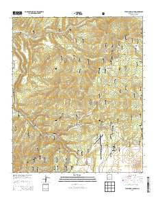
Telephone Canyon, New Mexico, USGS topographic map dated 2013.
Includes geographic coordinates (latitude and longitude). This topographic map is suitable for hiking, camping, and exploring, or framing it as a wall map.
Printed on-demand using high resolution imagery, on heavy weight and acid free paper, or alternatively on a variety of synthetic materials.
Topos available on paper, Waterproof, Poly, or Tyvek. Usually shipping rolled, unless combined with other folded maps in one order.
- Product Number: USGS-7796042
- Free digital map download (high-resolution, GeoPDF): Telephone Canyon, New Mexico (file size: 38 MB)
- Map Size: please refer to the dimensions of the GeoPDF map above
- Weight (paper map): ca. 55 grams
- Map Type: POD USGS Topographic Map
- Map Series: US Topo
- Map Verison: Historical
- Cell ID: 44486
- Datum: North American Datum of 1983
- Map Projection: Transverse Mercator
- Map Cell Name: Telephone Canyon
- Grid size: 7.5 X 7.5 Minute
- Date on map: 2013
- Map Scale: 1:24000
- Geographical region: New Mexico, United States
Neighboring Maps:
All neighboring USGS topo maps are available for sale online at a variety of scales.
Spatial coverage:
Topo map Telephone Canyon, New Mexico, covers the geographical area associated the following places:
- Eckleberger Canyon - West Salt House Tank - Beaverdam Canyon - Pasture Canyon - Brennand Ranch - Perry Canyon - Rocker Canyon - Hail Canyon - Telephone Canyon - Feathery Hill - Gwynn Cienega - Elk Mountain - Turkey Park - Telephone Tank - Water Canyon Tank - Ridge Tank - Rainy Mesa Camp - Rainy Mesa Tank - Elk Mountain Divide - Dark Canyon - Gilson Ranch - Rock Tank Number Two - Elk Horn Canyon - Eckleberger Hill - Sheppard Tank - Negrito Airstrip - Sheepherders Baseball Park - Rock Tanks - Gwynn Tank - Top Tank - Logger Spring - Gwynn Canyon - Water Canyon - Salthouse Canyon - Eckleberger Spring - Gwynn Camp - Elkhorn Spring - Sheppard Canyon - Yequas Park - Negrito Work Center
- Map Area ID: AREA33.62533.5-108.625-108.5
- Northwest corner Lat/Long code: USGSNW33.625-108.625
- Northeast corner Lat/Long code: USGSNE33.625-108.5
- Southwest corner Lat/Long code: USGSSW33.5-108.625
- Southeast corner Lat/Long code: USGSSE33.5-108.5
- Northern map edge Latitude: 33.625
- Southern map edge Latitude: 33.5
- Western map edge Longitude: -108.625
- Eastern map edge Longitude: -108.5


