
~ Taylor Peak NM topo map, 1:24000 scale, 7.5 X 7.5 Minute, Historical, 2013
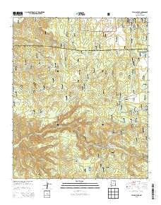
Taylor Peak, New Mexico, USGS topographic map dated 2013.
Includes geographic coordinates (latitude and longitude). This topographic map is suitable for hiking, camping, and exploring, or framing it as a wall map.
Printed on-demand using high resolution imagery, on heavy weight and acid free paper, or alternatively on a variety of synthetic materials.
Topos available on paper, Waterproof, Poly, or Tyvek. Usually shipping rolled, unless combined with other folded maps in one order.
- Product Number: USGS-7796022
- Free digital map download (high-resolution, GeoPDF): Taylor Peak, New Mexico (file size: 37 MB)
- Map Size: please refer to the dimensions of the GeoPDF map above
- Weight (paper map): ca. 55 grams
- Map Type: POD USGS Topographic Map
- Map Series: US Topo
- Map Verison: Historical
- Cell ID: 44388
- Datum: North American Datum of 1983
- Map Projection: Transverse Mercator
- Map Cell Name: Taylor Peak
- Grid size: 7.5 X 7.5 Minute
- Date on map: 2013
- Map Scale: 1:24000
- Geographical region: New Mexico, United States
Neighboring Maps:
All neighboring USGS topo maps are available for sale online at a variety of scales.
Spatial coverage:
Topo map Taylor Peak, New Mexico, covers the geographical area associated the following places:
- Upper South Water Tank - Boiler Peak - Lockney place - Scales Canyon - Keith Tank - Stiver Well - Squaw Creek Tank - South Water Tank - Paramount Canyon - Tin Mines - Hardcastle Canyon - Scales Windmill - Alexander Canyon - Scales Creek Spring - Taylor Peak - Pawnee Association Mine - Miners Tanks - Alexander Cienega - Boiler Spring - Kimberly - Hardcastle Tank - Inman Tin Prospect - Inman Ranch - Indian Association Placer - Silver Drip Mine Area - Spring Tank - Adams Tank - Rockcore Tank - Tin Tank - Doagy Tank - Miner Tank - Sawmill Tank - Greer Tank - Clifford Tank - Don Dunk Tank - Rocky Tank - Stiver Canyon - Crooked Tank - Burnt Cabin Flat - Scales Creek Claim Group - Alexander Peak
- Map Area ID: AREA33.533.375-108-107.875
- Northwest corner Lat/Long code: USGSNW33.5-108
- Northeast corner Lat/Long code: USGSNE33.5-107.875
- Southwest corner Lat/Long code: USGSSW33.375-108
- Southeast corner Lat/Long code: USGSSE33.375-107.875
- Northern map edge Latitude: 33.5
- Southern map edge Latitude: 33.375
- Western map edge Longitude: -108
- Eastern map edge Longitude: -107.875


