
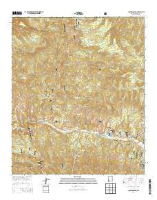
~ Copperas Peak NM topo map, 1:24000 scale, 7.5 X 7.5 Minute, Historical, 2013
Copperas Peak, New Mexico, USGS topographic map dated 2013.
Includes geographic coordinates (latitude and longitude). This topographic map is suitable for hiking, camping, and exploring, or framing it as a wall map.
Printed on-demand using high resolution imagery, on heavy weight and acid free paper, or alternatively on a variety of synthetic materials.
Topos available on paper, Waterproof, Poly, or Tyvek. Usually shipping rolled, unless combined with other folded maps in one order.
- Product Number: USGS-7791485
- Free digital map download (high-resolution, GeoPDF): Copperas Peak, New Mexico (file size: 39 MB)
- Map Size: please refer to the dimensions of the GeoPDF map above
- Weight (paper map): ca. 55 grams
- Map Type: POD USGS Topographic Map
- Map Series: US Topo
- Map Verison: Historical
- Cell ID: 10058
- Datum: North American Datum of 1983
- Map Projection: Transverse Mercator
- Map Cell Name: Copperas Peak
- Grid size: 7.5 X 7.5 Minute
- Date on map: 2013
- Map Scale: 1:24000
- Geographical region: New Mexico, United States
Neighboring Maps:
All neighboring USGS topo maps are available for sale online at a variety of scales.
Spatial coverage:
Topo map Copperas Peak, New Mexico, covers the geographical area associated the following places:
- Buck Hannen Mountain - Meadow Creek - Copperas Vista - Lake Roberts Heights Census Designated Place - Hill Canyon - Salt Creek - Alum Spring - Thirtytwo Tank - Spring Canyon - Lake Roberts Dam - Meerschaum Canyon - Mesa Campground - Salt Creek Spring - Lake Roberts Census Designated Place - Meerschaum Mine - No Name Tank - Lake Roberts Campground - Wild Horse Mesa - Spring Canyon Tank - Dry Lake Tank - Austin Roberts Vista/Point of Interest - Meerschaum Spring - Trout Valley Census Designated Place - Little Tank - Gila Flat Tank Number Two - Gila Flat Tank - Sapillo Creek Volunteer Fire Department and Rescue - The Military Road - Corral Tank - Little Victor Tunnel - Jordon Tank - Gila Flat - Upper End Campground - Senator Clinton P Anderson Wilderness Overlook - Lake Roberts - Seep Tank - Biddle Tank - Copperas Spring - Copperas Peak - Meerschaum Tank - Copperas Creek
- Map Area ID: AREA33.12533-108.25-108.125
- Northwest corner Lat/Long code: USGSNW33.125-108.25
- Northeast corner Lat/Long code: USGSNE33.125-108.125
- Southwest corner Lat/Long code: USGSSW33-108.25
- Southeast corner Lat/Long code: USGSSE33-108.125
- Northern map edge Latitude: 33.125
- Southern map edge Latitude: 33
- Western map edge Longitude: -108.25
- Eastern map edge Longitude: -108.125


