
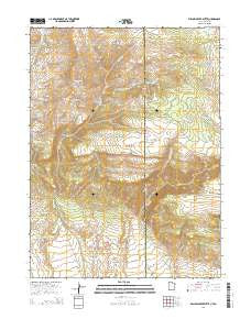
~ Willow Creek Butte UT topo map, 1:24000 scale, 7.5 X 7.5 Minute, Current, 2014
Willow Creek Butte, Utah, USGS topographic map dated 2014.
Includes geographic coordinates (latitude and longitude). This topographic map is suitable for hiking, camping, and exploring, or framing it as a wall map.
Printed on-demand using high resolution imagery, on heavy weight and acid free paper, or alternatively on a variety of synthetic materials.
Topos available on paper, Waterproof, Poly, or Tyvek. Usually shipping rolled, unless combined with other folded maps in one order.
- Product Number: USGS-7789742
- Free digital map download (high-resolution, GeoPDF): Willow Creek Butte, Utah (file size: 34 MB)
- Map Size: please refer to the dimensions of the GeoPDF map above
- Weight (paper map): ca. 55 grams
- Map Type: POD USGS Topographic Map
- Map Series: US Topo
- Map Verison: Current
- Cell ID: 49233
- Datum: North American Datum of 1983
- Map Projection: Transverse Mercator
- Map Cell Name: Willow Creek Butte
- Grid size: 7.5 X 7.5 Minute
- Date on map: 2014
- Map Scale: 1:24000
- Geographical region: Utah, United States
Neighboring Maps:
All neighboring USGS topo maps are available for sale online at a variety of scales.
Spatial coverage:
Topo map Willow Creek Butte, Utah, covers the geographical area associated the following places:
- Little Beaver Creek - O-Wi-Yu-Kuts Mountains - Cottonwood Draw - Honeymoon Spring - Birch Creek - O-Wi-Yu-Kuts Spring - O-Wi-Yu-Kuts Creek - Bender Mountain - Willow Creek Ranch - O-Wi-Yu-Kuts Draw - Whisky Springs - White Hill - O-Wi-Yu-Kuts Creek - Kleins Hill - O-Wi-Yu-Kuts Draw - Buck Knoll - Cottonwood Spring - Crumb Canyon - Bender Draw - Whisky Peak - Fighting Spring - Galloway Creek - Chokecherry Spring - O-Wi-Yu-Kuts Flats - Willow Creek Butte - Slippery Jim Spring - Clay Basin Meadows - Galloway Creek - O-Wi-Yu-Kuts Flats - Summit Spring
- Map Area ID: AREA4140.875-109.125-109
- Northwest corner Lat/Long code: USGSNW41-109.125
- Northeast corner Lat/Long code: USGSNE41-109
- Southwest corner Lat/Long code: USGSSW40.875-109.125
- Southeast corner Lat/Long code: USGSSE40.875-109
- Northern map edge Latitude: 41
- Southern map edge Latitude: 40.875
- Western map edge Longitude: -109.125
- Eastern map edge Longitude: -109


