
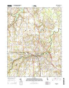
~ Milford DE topo map, 1:24000 scale, 7.5 X 7.5 Minute, Historical, 2014
Milford, Delaware, USGS topographic map dated 2014.
Includes geographic coordinates (latitude and longitude). This topographic map is suitable for hiking, camping, and exploring, or framing it as a wall map.
Printed on-demand using high resolution imagery, on heavy weight and acid free paper, or alternatively on a variety of synthetic materials.
Topos available on paper, Waterproof, Poly, or Tyvek. Usually shipping rolled, unless combined with other folded maps in one order.
- Product Number: USGS-7692182
- Free digital map download (high-resolution, GeoPDF): Milford, Delaware (file size: 32 MB)
- Map Size: please refer to the dimensions of the GeoPDF map above
- Weight (paper map): ca. 55 grams
- Map Type: POD USGS Topographic Map
- Map Series: US Topo
- Map Verison: Historical
- Cell ID: 29263
- Datum: North American Datum of 1983
- Map Projection: Transverse Mercator
- Map Cell Name: Milford
- Grid size: 7.5 X 7.5 Minute
- Date on map: 2014
- Map Scale: 1:24000
- Geographical region: Delaware, United States
Neighboring Maps:
All neighboring USGS topo maps are available for sale online at a variety of scales.
Spatial coverage:
Topo map Milford, Delaware, covers the geographical area associated the following places:
- Dogwood Meadows - Webb Manor - Haven Lake Estates - Freeman Corner - Spring Hill - Evergreen Acres - Abbotts Mill - Knotts Landing - Donovan Development - Hummingbird Hills - Milford - North Milford (historical) - Shawnee Acres - Milford Crossing - Colony West - Bowen Landing - North Shores - Farm View Park - The Heath - Stanley Manor - South Milford (historical) - Church Hill Village - Thompsonville - Woods Haven - Hall Estates - Lynch Heights - White Oak Mobile Home Park - Shawnee - Brown Street - Country Club Estates - Lakewood Development - Wisseman Acres - Eastman Heights - Lakewood - Milford Meadows - Chestnut Knoll
- Map Area ID: AREA3938.875-75.5-75.375
- Northwest corner Lat/Long code: USGSNW39-75.5
- Northeast corner Lat/Long code: USGSNE39-75.375
- Southwest corner Lat/Long code: USGSSW38.875-75.5
- Southeast corner Lat/Long code: USGSSE38.875-75.375
- Northern map edge Latitude: 39
- Southern map edge Latitude: 38.875
- Western map edge Longitude: -75.5
- Eastern map edge Longitude: -75.375


