
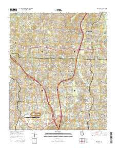
~ Kennesaw GA topo map, 1:24000 scale, 7.5 X 7.5 Minute, Current, 2014
Kennesaw, Georgia, USGS topographic map dated 2014.
Includes geographic coordinates (latitude and longitude). This topographic map is suitable for hiking, camping, and exploring, or framing it as a wall map.
Printed on-demand using high resolution imagery, on heavy weight and acid free paper, or alternatively on a variety of synthetic materials.
Topos available on paper, Waterproof, Poly, or Tyvek. Usually shipping rolled, unless combined with other folded maps in one order.
- Product Number: USGS-7536185
- Free digital map download (high-resolution, GeoPDF): Kennesaw, Georgia (file size: 38 MB)
- Map Size: please refer to the dimensions of the GeoPDF map above
- Weight (paper map): ca. 55 grams
- Map Type: POD USGS Topographic Map
- Map Series: US Topo
- Map Verison: Current
- Cell ID: 23330
- Datum: North American Datum of 1983
- Map Projection: Transverse Mercator
- Map Cell Name: Kennesaw
- Grid size: 7.5 X 7.5 Minute
- Date on map: 2014
- Map Scale: 1:24000
- Geographical region: Georgia, United States
Neighboring Maps:
All neighboring USGS topo maps are available for sale online at a variety of scales.
Spatial coverage:
Topo map Kennesaw, Georgia, covers the geographical area associated the following places:
- Arden Lake - Audubon Forest - Parkwood Commons - Brookwood Estates - Powell Station - Kellogg Creek North - Colony Woods - Hamby Place - Jamerson Forest - Skyridge - Deerfield - Shadowbrook - Lansdowne - Land of Lakes - Spring Valley Mobile Home Park - Village Green - Allatoona Pass - Kellogg Creek - Lakeside Hills - Kings Crossing - The Woodlands - Addison Heights - Blackwell Chase - Cambria Hills - Lake Pointe - Hickory Forest - Tyson Estates - Cherokee Estates - Oak Grove Estates - Noonday - Sturbridge - Kingridge West - Northridge Estates - Gibson Acres - Nowlin Estates - Abington Green - Pine Valley Farms - Heritage Place - Giles Crossing - The Woods at Colony Crossing - Woodstock - Willow Creek - Kennesaw - Stir Up Manor - Lake Forest - Ashley Forest - Cherokee South - Glenell - Timberlake North - Cherokee Mobile Home Park - Motes Hill - Sherwood Forest - Bascombs Springs - Ridgewood Estates - Shadowood Mobile Home Park - Springfield - The Crossroads - Kingridge Estates - Independence Walk - Sumpter Ridge - Cross Creek - Wood Glen - Southfork - Joshua Landing - Cardinal Woods - Bells Ferry Place - Indian Valley Estates - Cherokee Forest - Falcon Hills - Chestnut Hill - Woodstock Station - Stockwood Estates - Breeze Hill Estates - Kingridge North - North Bridge Trace - Eastgate Mobile Home Park - Nowlin Station - Cobb Place Manor - The Arbors - Heritage Farms - Oak Creek Estates - Shallowford Forest - Pine Hill - Dobbs Estates - Savanna Place - Woodwind Station - Lake Latimer - Oak Grove
- Map Area ID: AREA34.12534-84.625-84.5
- Northwest corner Lat/Long code: USGSNW34.125-84.625
- Northeast corner Lat/Long code: USGSNE34.125-84.5
- Southwest corner Lat/Long code: USGSSW34-84.625
- Southeast corner Lat/Long code: USGSSE34-84.5
- Northern map edge Latitude: 34.125
- Southern map edge Latitude: 34
- Western map edge Longitude: -84.625
- Eastern map edge Longitude: -84.5


